Friday, January 25, 2008

Chasing Sunsets Above Lake George


On my day off for the holiday Monday I decided to change things up. Rather than shoot for a sunset, I'd sleep in and do an afternoon hike of a mountain on Lake Georges eastern shore.

While this area is amazingly close to where I live , really we've only done a handful of hikes in the region over the years. Lots of options on both shores and a short distance beyond including Black Mountain (done in 2001), Buck Mountain, Shelving Rock Mountain, Sleeping Beauty, Cat Head, Crane, and the Tongue Mountain Range (done in 2002). Since I'm headed back to the beautiful Tongue Range in a few weeks I narrowed it down to Sleeping Beauty or Buck Mountain.


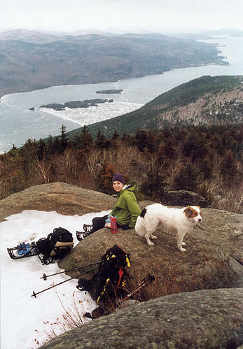
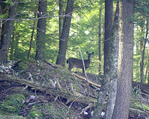
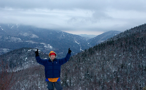
photo: Aim and Caney on Black Mountain c. 2003 with Lake George in the background.


Buck Mountain is a 2300ft mountain on the lakes eastern shore, with near 360* views of the surrounding lakes and mountains. Although the 300ft elevation of the trail head gives this hike a respectable 4000ft gain/loss over 6.4 miles, the hike up is downright gentle by northeastern and Adirondack standards. Most of the hike, if not all of it would make for a very fine ski if there is enough snow, and the skiers did not mind the several stream crossings to be navigated. Only the last 200ft or so is very steep (more than a few percent grade with dropoffs).

So I got to the trail head about 2:30pm. After lacing my boots and then deciding with the wind that my little 2.5 tripod would fair no worse than my 9lb tripod, I was off.

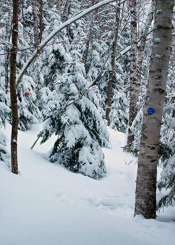
I left the snowshoes, there hasn't been much snow, and with the warm spell and rain I was actually expecting more ice. I took my crampons, but never even considered using them.

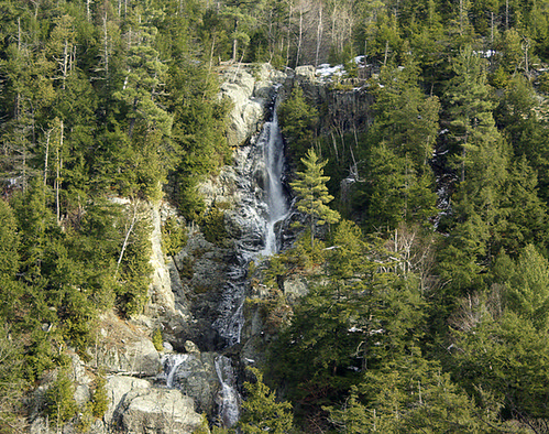
On the hike up I passed what looks like a nice little rock climb on a detached boulder. I didn't get close, but I snapped a shot of it to remind me to come back. It was a 40ft+ right leaning fist crack that joined up with another fist to off width crack to reach the top of the boulder. There are also a few waterfalls along the trail. In spring I am sure this is a great little hike with kids, or for photographers looking for cascades and wildflowers. I stopped off at 2 of them which in the end probably cost me the sunset from the summit.

The guide book said this approach (the south) was more scenic, and had views, but unless they were specifically talking about winter, I don't see how you could see a thing with the trees in bloom. Not only that, but graded climbs are the pits, I like to feel like I am making progress and switch backs and wide trails make me feel the opposite.

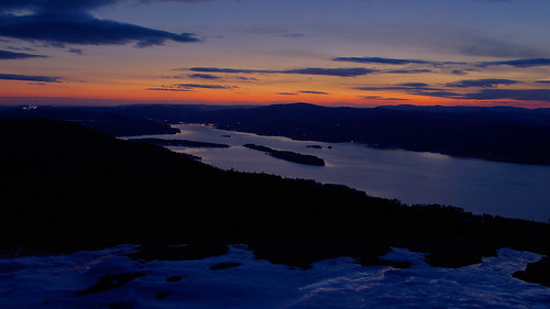
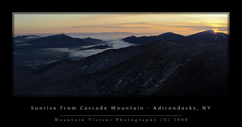
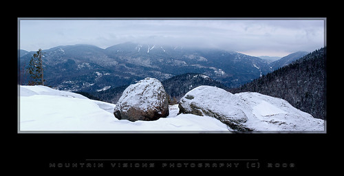
That said, there were great views of the sunset, and it was a beautiful day. The summit is very nice, with great views of the 22 mile Lake George, Vermont, Massachusetts, and the central Adirondacks.

I just got a wind meter to play with, so no more guessing the summit winds after this post, but for this last hike we'll have to go with my guess. I'm thinking 10-15mph with 20+mph gust. Looking at the Glens Falls weather station I probably wasn't far off, and the summits are always windier. In any case, photography at 6*F (-14C) in 20mph gust isn't all that appealing. So I put on my down jacket and worked really fast to get something before I got too cold.

I'd missed the sunset, actually saw it through the trees, and darn it was nice. One thing about sunsets, unlike the sunrise which is anticlimactic, a sunset isn't over till I say it is. And if you are persistent, you can create some really spectacular images that even the naked eye can't see because of the subtleties of the light.

So I took about 20 images (ranging from 1/15s to 1/2s) with my camera on a tripod and a cable release to activate the shutter, while I blocked the wind from hitting the camera. After about 10 minutes we cleared out pretty quick.

I hauled down the descent of the steep rock to get warm, by the time we hit the trees (about 2 minutes) I was toasty warm.

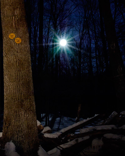
On the hike out the light of the rising full moon was hard to miss. It was casting shadows so strong I was forced to use my headlamp to counteract them. I got to a point where I was thinking about some photo ideas I had which involved a moonlit landscape, a large moon (close to full), and my trusty headlamp. This is all experimental but the results aren't bad for 4 attempts.

The results (20 seconds, f/13, tripod, cable release, headlamp to "paint" light on the tree):


The rest of the hike out was uneventful, other than wishing I had a set of short fat approach skis/snowshoe skis to glide out on.

Blogged with Flock

Monday, January 21, 2008

Mountaineer Dies In Avalanche On Mt Washington

Although you'd have to read all the stories to get the full story, it seems Peter Roux was not a Tennessee warm blood, but in fact a native of Maine.

He was climbing a technical climb called Odell's Gully which is a NEI 3 (a mid grade ice climb depending on conditions). I've climbed this myself a few years ago, and it's a stellar low to moderate grade climb. A skilled and confident ice climber could solo it if the conditions were good, and people do this all the time.

In this photo, the depression to the left (center) is South Gully, the right (center) depression is Odell's, and behind the big buttress all the way to the right is Pinnacle Gully.


Below is a more close up view of Odells from the base of the ravine. When you are down in there there are all sorts of contorted trees from the frequency of avalanches.

Oddly the conditions were between high and considerable avalanche danger that day based on the daily USFS Snow Ranger avalanche report found both online and posted on boards at the base of the Ravines. The Snow Rangers conduct avalanche condition test daily.

via www.tuckerman.org (USFS Snow Rangers):

We send our deepest condolences and thoughts to the family and friends of a fellow mountaineer who was killed in an avalanche in Huntington Ravine on Friday. The objective dangers in the winter mountains are many, which are contrasted by their extraordinary beauty, and the rejuvenation and peacefulness they can bring us. These factors together create the challenges that give us the intense fulfillment as human beings and keep us coming back time and time again. We must be ever on the lookout for all the hazards we face while pursuing our mountain passions. The mountains will be here another day.We will post an accident summary on tuckerman.org later today or tomorrow.

If there is a lesson to be learned, based on scattered information, don't risk climbing avalanche prone terrain alone during high or considerable avalanche danger. Even in the best conditions accidents can and do happen, the further you stack the odds against you, the more likely it is for things to go wrong. As the Snow Rangers put it, "the mountains will be there another day."

photos linked from www.tuckerman.org

Climber Dies On Mount Washington

By LORNA COLQUHOUN

New Hampshire Union Leader Correspondent

12 hours, 38 minutes ago

PINKHAM’S GRANT – The body of a climber killed Friday in an avalanche on the slopes of Mount Washington was recovered this weekend, according to U.S. Forest Service snow rangers.Peter Roux, 39, of Bartlett, Tenn. had been climbing alone Friday at Odell Gully, in Huntington Ravine and was reported by a friend as overdue just before 9:30 p.m. Friday.Snow rangers organized a search on the eastern side of Mount Washington and conducted an initial search between 10 p.m. and midnight.His body was found at about 7:15 a.m. yesterday. An investigation concluded that while Roux was climbing in the gully, an avalanche was triggered, carrying him down the slope.Avalanche conditions are provided daily in the winter at www.tuckerman.org and those conditions were rated as "high" on Friday. Today’s conditions, according to the report posted this morning, are "considerable," meaning “natural avalanches are possible and human triggered avalanches are probable.”

Union Leader - Manchester, New Hampshire


Tuesday, January 15, 2008

3rd Time Is The Charm: Sunrise On Cascade Mountain

After 3 consecutive weekends of searching for a sunrise, I finally got one.

In my pursuit of sunrises, I am finally getting my fat ass in shape. After being in great shape to end the summer, my back was bothering me in October, nothing ever happened, but there is a feeling that anyone with disc issues knows, and I had it, causing me to put off my second 10 day paddling trip. It worked out because it rained torrentially for almost all 10 days.

I'm not a fair weather paddler or hiker, but 10 days of pouring rain is depressing, and even after my back was feeling like it wasn't an issue I bailed out and decided on work rather than waste a week.

Nevertheless, good intentions and excitement for winter turned to getting lazy as the winter was slow to arrive. Fitness is fleeting and once it's gone it's a pain in the butt to get it back. I'm going to venture to say, despite working out hard in November, by Jan 1st I was in the worst fitness I've ever been in.

So very slowly I am working my way into shape by chasing sunrises up some of the smaller Adirondack peaks, each one getting progressively harder (or easier if you look at it from a fitness standpoint).

Enough with the discussion of my seemingly 50 year old cardiovascular system, my weak muscles, and Krispy Kreme physique.

Sunday, I left home at 3:20am and got to the Cascade trail head at 4:55am.

After putting on my boots and gaiters, and making sure I didn't forget anything, I was on the trail by 5:20am.

I started to leave my snowshoes at the trail head, but since I took them I decided to wear them rather than lash them to my pack along with my 9lb tripod, and crampons. Big mistake! After about 2 minutes the trail turned to rock and mud. So I was forced to hike in the trees which was not too troublesome. The forest to Cascade is uniquely thin for the Adirondacks, and bushwhacking (albeit only meters from the trail) is relatively fast and unencumbered.

Walking on the frozen snow was like walking on styrofoam. No powder to be found in the Adirondacks after a week of record temps and rain.

At about 3000ft, approx 900 vertical feet from the trailhead, the snow coverage was more consistent and it was back on the trail full time. By 3500ft there was snow covering all of the ground for the first time.

The hike was under a star filled sky, which occasionally found me turning my headlamp off just to take in the starlight.

At about 3700ft there is a steep rock section which in a typical winter is covered with deep snow till the top of the slab where it is a sheet of 20* ice. Unfortunately, despite the great December, the mountains resemble early November rather than January.

At this point I removed my snowshoes, and put on my crampons, with the snow being rock hard and bulletproof, I ditched my snowshoes deep in the trees and hiked the rest of the way in crampons.

The summit of Cascade is a long fairly flat ridge, although somewhat slightly technical with a few scrambles to get to the high point. It's a typically non nondescript Adirondack summit that is often considered the easiest 4000 footer in the Adirondacks. It's not that Cascade is not a pretty summit, it actually reminds me of a mini Mount Mansfield when you come out of the scrub line on Sunset Ridge with the big expanse of exposed ridge, but it's not a conical summit like most people envision most summits to be.

What can't be minimized are the spectacular views which take in almost all of the 4000ft peaks.

I got to the summit at 7:15, although it's a bit deceiving as I wondered if stopping to photograph lower would have been better, I wasted a few minutes evaluating vantage points. For some reason I've always liked the views below the summit much better than on top.

After 45minutes up there, in what was an unusually windless day, and actually fairly warm in the sun, we headed down and I considered hiking to Porter Mountain about .7 miles further.


I started down the trail to Porter but about 5 minutes into it I turned around. Unfortunately while I felt great, my heels had blisters (feet need to get in shape too), and I decided to head down.

The hike out was uneventful. Other than of course the typical weekend hordes that hike to Cascades summit. The solitude of 5am starts suit me, but it's always nice to talk to a few people on the way down, and more so with the smug satisfaction of knowing it's around 8am and you are done with the day!!! In all about 12 people were hiking up on my way out.

There is no such thing as a bad day in the mountains, but it's occasionally nice to see the sun rise, to see blue in the sky, and to see a few feet in front of your face. What was sad was the drive home through the mountain passes. Typically filled with waist deep snow, frozen ponds, and ice covering the cliffs, which in turn are covered by ice climbers. Instead it looked like late fall or early spring. Had I been in a coma for the last few months, I'd have guessed it was November.


technorati tags:, , , , , , , , , , , , , , , , , , , , , , , , , , , , ,

In Search Of Blue Mountain

The weather forecast wasn't good for my second sunrise hike of the year. Low fog, clouds, and potentially rain or snow.

My philosophy on weather is 1) there is no good weather, just weather 2) I'll find out when I get there.

The truth is, the best and most unique photos are taken when everyone else is at home watching TV, or keeps their camera safely ensconced in it's waterproof case.

The best sunrises are the ones that just barely happen, and the best days in the mountains
are the ones you actually spend in the mountains.

I've driven by Blue Mountain perhaps 100+ times over the years, and despite it's popularity never hiked it; I've even skied around the base, but never up it. I've never been a tick list kind of person, so if I like a summit, or a trail, I have no problems hiking it a few times a year. By definition it's called freedom, whereas a list is called work. With not being a tick list type of person and just winging it more often than not, I sometimes take a little while to get to all the places I have in mind.

Blue Mountain is by no means a wilderness summit, it is one of the few public Adirondack peaks with visible antennae, a road, and buildings. It is however, also not totally developed, and only allows for non motorized hiking access to the public.

Part of why I never really made the pilgrimage to Blue Mountain are those summit structures. I'm OK with a fire tower, they are part of Adirondack history, but I hate roads, modern communications antenna, and in general developed summits. If you know me, you know I consider a developed summit ruined, and it's the main reason I never hiked Whiteface (although I have skied to the top of it). It took me till 2006 to hike Mount Mansfield, Vermont's highest summit, which is now one of my favorite Northeast peaks, in spite of the fact it has a ski resort, a road and communications equipment. Sorry Vermont, but if you tried any harder to ruin that beautiful mountain, you would have made it plainly obvious. Good thing you are a state filled with environmentalist, or just think what could have happened to Mansfield.

Headed to Blue Mountain, I got a late start and forgot my trekking poles, so I missed the sunrise by about 15minutes, but I'm fairly certain there was none. I never even saw the faintest of golden light anywhere.

The forest from 2200 feet when I started at 6:30am was completely fogged in, and it never got better. Even on the windy summit, it was so foggy I almost didn't see the fire tower at first.


Between the dampness, and the warmth I was struggling on this little 3700ft peak. Caney would come down the trail, yelp, and then sprint back up. Yeah, he's a regular Lassie, only Lassie would have removed my pack, carried it to the summit and come back down to drag me up with her mouth. All my dog does is tell me that it's getting late and I need to pick up the pace!


It was actually so warm, and being warm natured myself, I contemplated removing my shirt entirely as I was dripping with sweat. However, I felt if I somehow encountered another group and was hiking shirtless, with the side zips on my goretex completely opened in the middle of winter, they'd surely think I'd gone mad and have me committed.

I'd guess the temps were in the low 30's at the start of the hike around 6:30am.

The only relief was the at times strong winds on the summit, which believe it or not felt like stepping into air conditioning on a hot summer day. We spent about 45 minutes up there before Caney became very cold, and I was adding layers. What is odd is wind generally clears fog, but there was fog for most of the trip down.

The trip down was uneventful, I did my best to create false trails for the next group, as i hate hiking downhill in winter on hard packed snow. Anytime I saw a path through the forest I went cross country through the powder, and met back up with the trail at some point further down.


technorati tags:, , , , , , , , , , , , , , , , , , , , , , , , , , , , , ,

Blogged with Flock

This Blog Has Been Supersized...

If you regularly visit this blog, and use a screen resolution below 1000pixels wide this blog might not display properly.

The blog has been resized so the center column can hold a reasonable 500pixel width image.

Today most monitors and graphics cards comfortably support 1024x768 pixels so if your still using 800x600 resolution it might be a good time to resize your screen and take advantage of the larger footprint that a higher resolution offers.

To do this, simply right click your windows desktop, select properties. Then select settings and select 1024x768 if you have a CRT monitor. If you have an LCD it might be wide screen so just select the closest 1000 pixel resolution.

Sorry for the inconvenience but I hope it will make the blog a better viewing experience.

Justin

Blogged with Flock

Friday, January 4, 2008

Mountain Visions New Years Day (almost) Sunrise On Rooster Comb


Leaving home at 3:30am and heading for Keene Valley for a 6:00am start, I thought I might sneak in a New Years sunrise before the weather turned snowy. Sometimes you just don't luck out. Despite the weather looking like it would cooperate and solid selection on the mountain, the sun never rose.

Well, obviously it rose, or you wouldn't be reading this, it just wasn't visible through the thick cloud cover.

After consulting my memory and then National Geographic Topo! Norteast I settled on a few possible options. The criteria were decent views, less than 3.5 miles and fairly easy to ascend. Afterall, I was hiking on 24 hours without sleep by the time I got back down. Rooster Comb, Hopkins, Noonmark, and Cascade all came to mind.

After checking out the azimuth of the sunrise and using the line of sight tool on the Topo! to make sure I had a clear view of the heading, I opted for Rooster Comb which was a fairly short 1:15 minute drive from home.

Rooster Comb is the traditional start of the Great Range Traverse and a mere 2700ft compared to the 4000ft height of the rest of the peaks beyond Hedgehog Mountain. It's about 3 miles from the trail head and a fairly nice hike with a lot of switch backs. The mountain has a nice open summit with 270* views, but the views are about average because the surrounding peaks block out any significant long range views. However, you peer right down Keene Valley, and the sun just happened to be rising behind the valley.

After putting on my boots and gaiters I was a little ahead of schedule but the weather wasn't looking like the 10am snow start that was predicted. After listening the the comedy channel on Sirius for a few minutes longer we started out at 5:50am. By the time we signed in at the register and I adjusted my poles and snowshoes it was 6am.

The issue wasn't getting to the summit early for me, but for Caney. He doesn't have a winter coat grown in yet and he gets cold easily when not moving, so getting there without too much standby time is key.

The weather was great, I hiked in my usual goretex bibs, and a thin base layer top under my goretex shell. Warm enough to unzip the pit zips and hike gloveless without a hat. When I left at 3:30a the temp in Lake Placid was about 18F so I'm guessing it was about 15-20F when we started, and windless.

After about 45minutes it was light enough to hike sans headlamp, but it was also snowing quite hard. Then just as I'd given up hope for a clean sunrise the snow stopped and it seemed to be getting clearer.

As we approached the summit, I could see some orange around the horizon but the sunrise was not to be. While it stopped snowing for about 45 minutes, it never cleared up and that faint orange glow behind the clouds was as good as it got.

We spent 25 minutes up there, of course the wind really picked up after sunrise (gusting to 25mph in Plattsburg at sea level), but nothing ever got photographically interesting. The trip down is fairly steep at the top, and well below the summit there are several chances to cut the switch backs and go cross country to link up with the trail. We really cut a few minutes off here and there and the deeper powder (about 3ft+) was more interesting then the well packed trail.

The hike out was very snowy with perhaps an inch falling. The poor weather was a great test for the weathproofness and usability in the cold of the K10D, as I looked to salvage the morning from a photographic standpoint . The camera and FA 28-70 f/4 lens handled the weather quite well, and even on digital this lens as been a workhorse for me since I bought it in 1998. (perhaps one of the best 28-70 zooms made from a performance to size standpoint, and only a stop slower but much lighter than most "pro" 2.8 zooms which I prefer not to carry while hiking).

The drive home was spoiled by flat landers and downstaters. Yep, I'm a geographic bigot and proud of it. If you can't handle the snow don't come to the North Country! My drive time doubled as people made their way home to their meager existence, in a life of expensive misery, in the sprawling metropolis of downstate NY and the equally crappy New Jersey.


So Happy New Year!!!

(Day 1 of 365...and I'm 1/1, solid 1.000 batting average, undefeated!!...if I could only keep this average till next Jan 1st I'd litterally be a happy camper).


Me 1-1-08 @ 7:30am on the summit of Rooster Comb Mtn.

technorati tags:, , , , , , , , , , , , , , , , , , , , , ,

Blogged with Flock