Saturday, September 24, 2011

Taking Dix from both ends can leave you with a Whiteface!

Aim ascending Whiteface Ski Slide #1

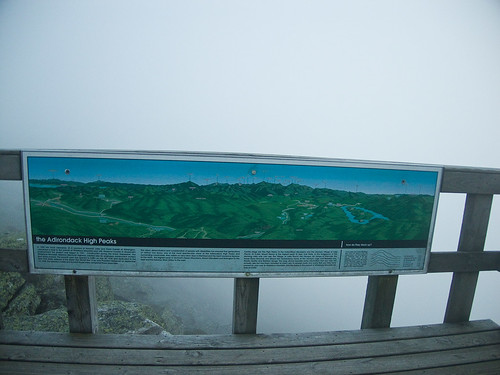
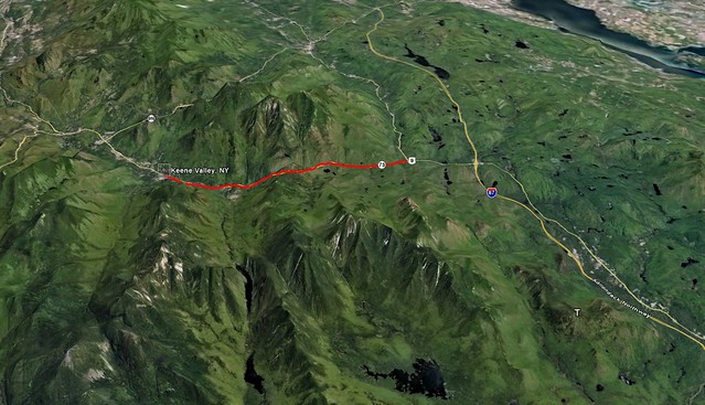
Following our removal from the Dix Wilderness by the DEC, we had to find alternate plans for the remainder of our vacation. Slide climbing had always been on the agenda for the second half of the trip, so with 3 major slide filled wilderness areas closed, my eyes turned to Whiteface.

Approaching and descending from a ski slope would seem to be easy. As you drive by them on the road you see grassy fields that look like a pleasant way to ascend and descend a mountain. Perhaps Whiteface is different than other slopes, but it was anything but a leisurely walk.

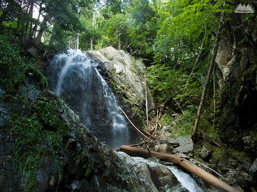
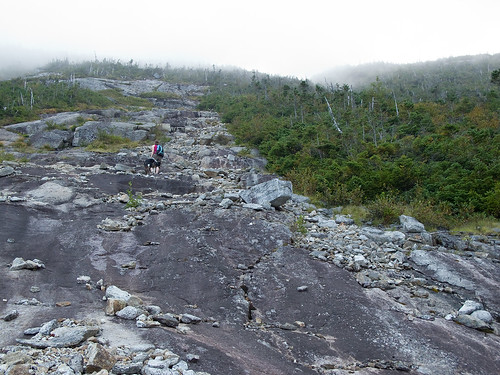
The ascent was fine. We actually took the Stag Brook Trail -lower and upper- which gained about 1500ft or so. This was in the trees, on a trail parallel to the beautiful rushing Stag Brook with it’s numerous waterfalls and cascades. I don’t know if Stag Brook is typically dry in summer, my guess is that it normally doesn’t flow quite this much. But following hurricane Irene, it was quite full and beautiful.

Stag Brook Falls

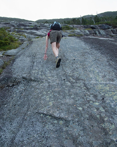
At the top of Stag Brook trail, we began the ascent via the ski slopes. Immediately the 80+F (26C) heat with high humidity became an issue. Mid summer heat and humidity in September, on a shadeless open slope = fun times.

Understanding why you ski down them!

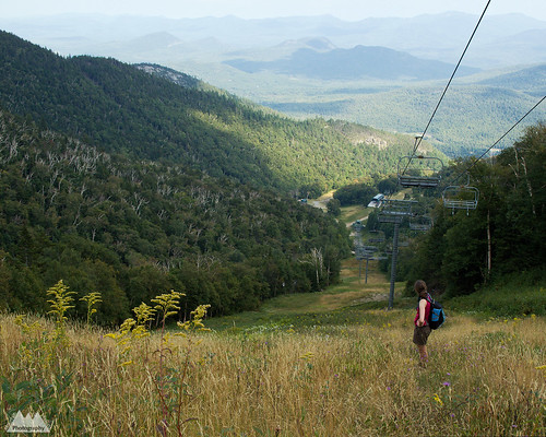
The slopes are actually quite pretty, many wildflowers and butterflies to be seen during the ascent. We could also see our objective quite clearly. Both the summit of Whiteface and the slide bowl -or as my wife refers to it, the hell hole.

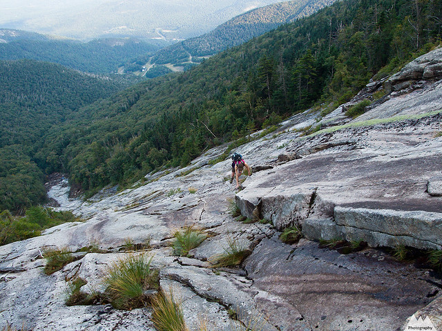
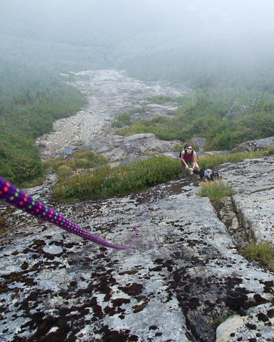
It was about 4pm when we finally got to the base of the slide. Slides 1 and 3 are immediately visible in the bowl. Just bear left and start up #1, #3 is slightly to the right (center). #2 two splits near the upper half of #1, and #4 appears to require some bushwhacking to gain the base, but nothing heinous. My next trip here I will be doing Ski Slide #3 and then traversing over to Ski Slide #4 to summit via the crux pitches of #4. For this trip though we just did the easiest of the four, #1.

The slide was relatively dry as a whole, but there were many wet sections and many streams of water flowing down. Mixed in were a few slimy sections. For this reason we zig-zagged around a lot of the slide seeking the driest terrain versus the easiest terrain. Typically, I look for the harder climbing on class 2, 3 and 4 terrain to make things interesting, but this time we ended up on steeper and drier sections because of necessity. Oddly, I usually feel like the climbing is easy, but on this slide I felt like it was steeper and more dangerous than the trip reports suggested. I might be getting soft, or I might just have been concerned about Colvin.

A concerned Colvin watches the ascent

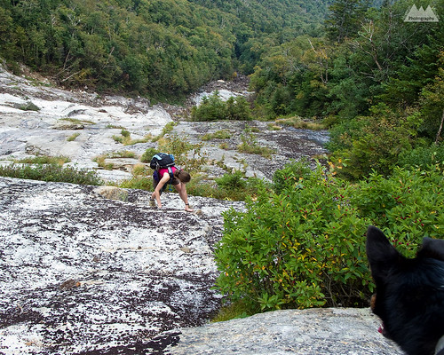
Colvin climbed the class 3 slide with relative ease, but because of his extreme concern and loyalty for us, he put himself in dangerous positions several times by returning down from difficult sections to “assist” or encourage us. There were 3 sections where I roped Colvin. He was wearing his Ruff Wear Doubleback technical climbing harness, and I used a hip belay and 8mm static cord to give him a little assistance over some fairly steep sections that were above significant runout. In these sections, I felt a fall could become dangerous beyond the initial impact. It’s quite funny, really, but he is very comfortable climbing while roped. Whereas my last dog, Caney, who was a much better climber, almost human good on technical terrain, did not like being roped up.

Final ascent before bushwhack
The mental crux of any of these longer semi-technical climbs is the exposure. There are sections of trail throughout the Adirondacks with slabs this steep, or even steeper, but few involve looking back down at hundreds, or even 2000ft, of unbroken fall beneath you. There were few sections on this slide where there was potential for fall for even a novice climber with a grasp of fundamentals, but if a fall were to happen, it could be fatal. I would say that if you were to fall on the first 200-300 vertical feet of the slide, you could potentially fall all the way to the bottom without stopping depending on your path during the fall, though more than likely you would stop. The higher up you got on the slide, the less steep it became. In many spots any sort of significant fall was near impossible, and it was just like hiking any steep, slabby trail.

Climbing the slabs - Whiteface Ski Slide #1
Falling on a slab climb or slide is actually quite serious. More serious in my opinion than a beyond vertical rock climb with good protection. When you fall it’s not a matter of if you will hit something, but how far you will slide before you stop. Skin and rock don’t mix well. Even a minor fall can lead to weeks of healing. That said, I’m a confident, and I hope, a good friction climber, slabs have never bothered me, and I enjoy climbing them. Generally speaking, people either love or hate slab climbing. There is no middle ground.

The left side of slide #1, though not extreme left, is more ledgy with verticalish steps of 3-10ft. Staying towards the center is more a mix of ledges and slab, while far right is mostly smooth slab. In dry conditions, the right side seems like it’s the best route for friction climbing. In wetter conditions, the center left gives a nice mix of rest ledges with secure stances, dry friction, and good positive holds.

The extreme left, which would be on the treeline, is very wet, muddy and also slimy. I would not consider this an option unless it was already raining and you were using the trees for assistance. Even then, you might be better off towards the center or right sides.

While the easiest of these slides are really glorified hikes, and the hardest are technical rock climbs, I’d recommend people have some climbing experience before undertaking them. Also, I see a lot of hikers bring ropes with them while hiking, but few actually know how to use them. Figuring out a rope 750ft off the deck of a slide really isn’t the ideal place. Though I brought a rope, I did not bring human harnesses. I could have made a diaper harness from the webbing I had, but I think it’s a good idea to have harnesses for novice climbers and 100ft of rope, along with some webbing. Coincidentally, I did notice an old sling with a rappel ring on tree that had long since washed away. Apparently someone either descended the slide or got sketched and bailed on it.

Clouding In

When Aim, Colvin and I reached the top of the slide we were on the right side of the slide. We were greeted by a wet 15ft slab of about 45*, which was above a 5ft shelf. We scanned for a herd path before committing to the upper section but did not see one. I climbed the crack to avoid the slab itself, then I belayed Colvin up the slab. The left-center looked easier, like it went further into the trees, but it was also wet and I preferred the safety of the crack system in the slab above us.

The best part of slide climbing, the bushwhack!

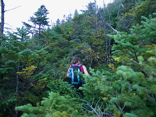
Once at the scrub line, we did a quick check for a herd path of any sort. One could not be found. Knowing Aimee’s desire to be done with the slide and get to the summit, I let her forge a path through the cripple brush. About 10 long minutes later, we climbed the last 150 vertical feet to the power cable path, and ascended to the summit station. Having escaped any sort of injurious behavior on the ascent to this point, I promptly fell into a crevice while entering the tourist section of the mountain.

Thanks for the reminder!

The summit of Whiteface had been in the clouds for some time while we were on the slide. When we reached the summit things hadn’t improved. Views were 20 feet tops and the sun was just about to set. A few quick summit photos and then we pulled out the map. I took a compass bearing for the ORDA trail we planned to use for descent. In hindsight, this wasn’t necessary, the summit station viewing area is marked with direction markers for tourist to use when viewing the distant mountains. However, the only other time I’d been to the summit of Whiteface was skiing to the top in the winter and I had no idea where the trails were, as the ski route simply goes up the summer tourist road. Better to be prepared while in shelter than dealing with a map in 30 mph winds and fog. We headed south for the ORDA trail, pretty quickly we spotted yellow blazes, and were on the ORDA descent trail.

Aim and Colvin on the cloud covered summit

All I can say about the ORDA descent trail is HOLY $h!%!!! Wow! I was expecting some sort of paved tourist descent to the ski lifts, but this trail was in fact steep and interesting. It even had ropes set up to lower yourself down at least 3 sections. Though only one was really necessary.

Whiteface Slide #1

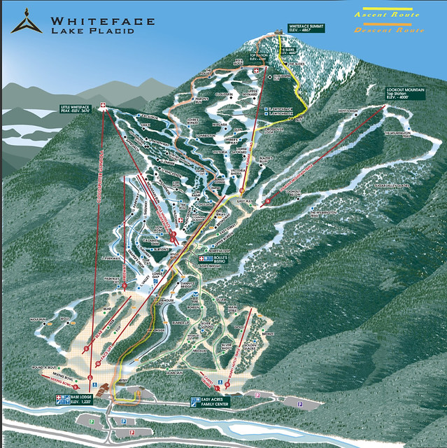
Unfortunately, this was the end of the interesting part of the day. Descending down the ski slopes in complete darkness, strong winds and occasional fog was interesting only in that we were not able to just plunge down the steepest slopes for a rapid descent. Having my mini headlamp, clearly anticipating a shorter day, I couldn’t see more than 30ft, so we took the longer moderate ski trails towards Little Whiteface, and then began a direct descent from Little Whiteface. (Coming back a few weeks later, I could see just how steep Niagara was, and was glad we didn't plunge down it's slabby decent).

Along the way, we crossed paths (literally) with a porcupine. While that was exciting in a horrific train wreck sort of way -we hate porcupines- the highlight of the knee busting, ankle twisting, back aching, filling loosening, brain jarring descent was seeing what I believe was a Fisher pop up in the grass about 50ft from us. His tightly spaced eyes and head movements led me to believe he was a predator, most likely a cat or weasel. He was directly downwind from the porcupine, and my guess he was hot on that bully of an animals tail...or rather head. 25 head bites later, that porcupine was going to be Fisher dinner.

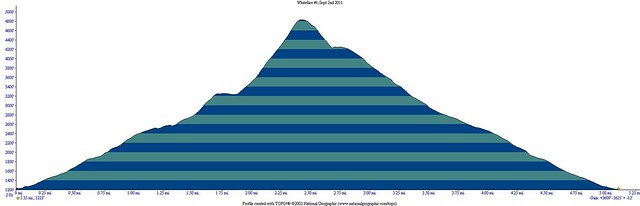
The descent went on forever, and finally at almost 9 hours into the day we arrived back at the car. I’m not sure of the total mileage, but I’d guess it was only about 6 miles. The total ascent/descent was 7500ft, which equates to well over 1000ft per mile. What really took so long was the ankle breaker scree on the ski slope descent. It was like walking on baseballs placed neatly on top of golf balls. That night and the next day, we felt like we’d done three times that distance. Even Colvin slept most of the next day. I’ve done 20 mile, 12,000ft gain and loss hikes this year and barely been sore the next day, so I was truly surprised how punishing the ski slopes were!

Whiteface Slide #1

All in all, it was a good day and a great adventure. Add this to your options for life outside the High Peaks Wilderness, but do yourself a favor, trust me on the ski slope brutality and figure out another way down the mountain! Even if you have to carry a sledge hammer to the summit to break your own femur with and call for rescue, it will be better than descending the ski slopes!

Long term consequences of improper streambed reconstruction in the Adirondacks post-Irene

Stream reconstruction on Styles Brook. Jay, NY. All photos courtesy Adirondack Council.
The Adirondacks are unique in concept and design, and because of the very nature of the patch work of public and private lands, the suspending of the permit process following Irene was both necessary and dangerous.

While people refer to the Adirondacks as a park, they really are nothing more than patches state forest preserve co-mingling with perhaps the nations most regulated zoning laws on private land.

Gulf Brook. Keene, NY. 
This, however, is a problem because, perhaps, no where else does there need to be such a fine balance between the needs of the people that live and work within the blue line and remaining true to article 14 of the New York State constitution. The the APA and article 14 are perhaps an impediment to life in this region, but they have prevented the Adirondacks from becoming another Catskills of the state. The idea that regulations have hindered growth is foolish, rather, they have made the Adirondacks relevant to both tourist and exploiters alike. They have also made the Adirondacks relevant in the hearts and minds of people from all over.

When Governor Cuomo announced a suspension of APA permits for rebuilding, I winced. Not out of selfishness, no doubt did cleanup and rebuilding need to be swift and without "unnecessary" red tape, but like with anything in life, it needed to be done correctly.

Following that bold announcement, the DEC did enact detailed guidelines, but many towns and DOT divisions either didn't receive them or chose to ignore them. It's human nature to be given a long leash and stretch it as far as you can.

At issue is the fact that permitting processes have not been entirely suspended. Water quality standards are still in effect. Dredging and channelization should only be occurring where there is "imminent threat to life, health, property, the general welfare and natural resources." The straigtening of channels and other man made changes to various brooks and rivers is actually potentially a threat to human lives and property, under far less intense conditions than Irene brought.

During Irene, nature showed us how in control it still is despite our technology and repeated attempts to control it. The DEC, despite budget and staffing cuts, still employs many intelligent and passionate people capable of making correct decisions necessary for long term success. Many of those people live, work or recreate in the towns affected by Irene flooding, and they certainly do not want to hamper the process of reconstruction and flood prevention. So it amazes me that the town supervisors and residents are so gung-ho about ignoring APA-DEC warnings and doing their own thing with the idea it can be fixed later.


Roaring Brook, now a ditch with water.
Fixing it later means fixing it FOLLOWING the rest of this years tropical storm season and next springs melt off. Fixing it correctly the first time means less chance of future flooding from insignificant rain falls. Remember this storm was a 500 year flood, not a regular occurrence, even in a region that is one of the wettest in the US.

Unfortunately, the towns and DOT divisions are intent on assuaging the fears of the residents -whom are also their constituents. However, to even have a shot at protecting those areas from Irene like flooding ever again, it is estimated some water ways would have to be 20ft deep and 200ft wide and constantly redredged. This simply isn’t practical, and the state would be better off relocating those residents and businesses within the 100 year flood zone to a different location. Furthermore, even heavily controlled waterways still are subject to flooding. Quite simply, water doesn't play nice with human interference, and trying to make it do so is only going to lead to bigger problems.

Entirely forgetting about the potential environmental impacts of improper stream bed restoration, which include reducing or eliminating trout habitat  and preventing tree regrowth on the banks of these brooks and rivers. Historically we've seen what bad flood control projects lead to, just look at Katrina. The Army Corps of Engineers is often at fault for massive flooding due to poor engineering and planning. It’s entirely possible that these poorly engineered flood control systems and stream reroutes that the DOT is doing, could actually cause flooding issues on much smaller floods than letting the streams naturally flow, or at most reverting them to pre-Irene state.

I sincerely hope these towns in the Adirondacks aren't attempting a quick fix, only to deal with bigger problems in a few years!


-
-
The Adirondack Councils statement of concern can be found here.

Tuesday, September 13, 2011

Dix Mountain Wilderness reopens effective 9/12/2011

More good news for all of us chomping at the bit to get back into the Dix Mountain Wilderness. Ok, that is pretty much me and a handful of people who need the 5 peaks for some patch. Nevertheless, the overlooked and under appreciated middle child of the Adirondack higher peaks wilderness areas is once again open for business and pleasure.

As a side note, my guess is the DEC never wanted to reopen the High Peaks as quickly as it did, but it bowed to pressure from the ADK and various local governments. After all, the High Peaks Wilderness complex is a cash cow for multiple towns in the Adirondacks. The Dix, however, was conveniently closed because it's monetary value to local governments is relatively small, while it's resource footprint for DEC staff was quite big during 73's reconstruction. With only the Elk Lake access point available, no local government benefited from revenues from hikers spending money while recreating. The irony, however, was that the Dix Mountain Wilderness saw relatively little damage and it's also the least trailed of the 3 closed areas.


STATUS OF DEC RECREATIONAL FACILITIES
September 12, 2011

AREA OPENINGS (9/12): DIX MOUNTAIN WILDERNESS and all trailheads along
Route 73 are once again OPEN, with the exception of the main Adirondack Mountain Reserve Trailhead at the Ausable Club.
DEC has now reopened the three wilderness areas and a majority of trails that were closed as a result of damage from Hurricane Irene. However, some trails remain closed in both the Eastern
High Peaks and the Dix Mountain Wildernesses due to significant amount of blowdown, washed  out bridges and eroded & cobbled trails .

TRAIL ADVISORIES (9/12): Trails that are not closed still may have bridges washed out and water levels in most rivers and brooks are at spring high water levels. Crossings may be impassable at this time. These trails may also have blowdown, eroded sections or flooded areas. Pay close attention as many trails have been rerouted to avoid heavily damaged sections and eroded drainages can be mistaken for trails. The ability to navigate with a map and compass
is important.

Monday, September 12, 2011

Route 73 from Exit 30 to Keene Valley is now open

Route 73, linking Keene Valley to the Northway (I-87) is now fully open. Initially only a single lane was planned to be open within 10 days, but the DOT, Governor Cuomo and private contractors put together an amazing feat and came out way ahead of schedule. Truly amazing based on the photos and descriptions of the level of destruction to Route 73.

Based on business numbers while the roadway was closed, it appears Route 73 truly is the lifeblood of Keene Valley. Business owners reported a 75% loss in business. However, this could also be attributed to the Adirondack Forest Preserve's; High Peaks Wilderness, Giant Mountain Wilderness and Dix Mountain Wilderness all being closed for much of that time. These happen to be 3 of the most popular wilderness areas in the park for 4 season recreation and contribute immensely to the local economies of surrounding hamlets. The Forest Preserve contributes over $1 billion yearly to the New York economy.

Full press release from Andrew Cuomo's office available here.

The red line on the map below outlines the section of Route 73 heavily damaged by Irene and now reopened to the driving public today. Good news, indeed, for leaf peepers, hikers, peak baggers, rock climbers and ultimately the business owners who benefit from the tremendous variety of recreational activities in America's premier weekend wilderness!

73 to KeeneValley

Friday, September 9, 2011

Scars of Irene on the Adirondack backcountry

This video is from the Adirondack Wild Center based in Tupper Lake, NY.

The aerial and ground based HD video is pretty compelling in both terms of destruction and the natural beauty of the Adirondacks. While watching it I couldn't help but be reminded why no matter where I am, I always seem to compare it to America's first wilderness -the Adirondacks.

Combined with the still images of the backcountry from the previous post, this should really start to put together the pieces of the puzzle that merely reading written reports left us unable to do.

Also of note, it appears this video was shot several days after the initial destruction, so things look pretty clean and orderly in the towns, in spite of the level of damage. Much of which was caused by relatively small streams jumping their banks. In Keene it was Gulf Brook, a stream that is less than 20ft wide most of the year, and that you can almost jump across in many sections just a few miles from Keene.

Those watching this from other parts of the country or world should be aware that the video covers a very small section of the New York State Forest Preserve, mainly the Eastern High Peaks Wilderness and surrounding towns. Though this is the most popular part of the Adirondacks, there are millions of acres that were largely unscathed from Irene, and also offer tremendous scenic beauty.

Thursday, September 8, 2011

Images of the the aftermath of hurricane Irene on the Adirondack High Peaks and John's Brook Valley

I highly advise anyone with some backcountry aspirations to take a look at the destruction -and in some ways, improvements- to the Adirondack backcountry as seen through the lens of Brendan Wiltse.

Some great photographs of the damage in an area not yet open to the hiking public: Hurricane Irene damage to the Adirondack High Peaks, John's Brook Valley Region, including several new slides along existing trails.

I say improvements because anyone that has hiked the Orebed trail will certainly appreciate it is no longer a steep, slick, slabby tree tunnel, but it now has some views and the trail is more like a true slide climb than an eroded hiking path. I always hated that trail, even more so when the ladders were missing this spring and early summer. Sadly, the Adirondack Mountain Club Pro trail crew was putting in new ladders just before the storm. Much of their work destroyed and mixed in with rubble from the slides.

Oddly, while a lot of damage was also done to lowland approach trails that is not good, the potential new routes up slides, and the opening up of the terrain on existing trails actually looks like it is a long term benefit. It will be interesting to see first hand just how different the views are off the mountains of the Adirondacks.

Also from Brendan's blog:

Saturday, September 3, 2011

Adirondack Park is still open for business post-Irene!!!

While en route to Whiteface Mountain and the Whiteface Slides on Friday (separate blog post/trip report), driving through Keene, Upper Jay, and many other areas of the Adirondacks, seeing the devastation created, in many places by relatively small innocuous brooks, really put things into perspective. Businesses, and worse, homes were destroyed. Peoples personal belongings put out to the curb or in there yards to be carted away. Beyond that towns pretty much cut off from the Northway and even other parts of the Adirondacks in what is the busiest month of the year. Labor Day through Columbus Day/Canadian Thanksgiving, this 6 weeks is perhaps the most important of the year for the bottom line of businesses. Labor Day is gone, there is hope that the roads and infrastructure can be ready for Columbus Day/Canadian Thanksgiving weekend to perhaps soften the blow.

There is tremendous misinformation about what is open, what is closed. And even on scene things were difficult to discern. 9N beyond Jay was closed last night, though I'd heard previously roads into Ausable Forks had reopened. 9N between Upper Jay and Keene is also open only to local traffic and because we already had made one mistake, we chose to not drive 9N to see how much of it is closed or if it is in fact passable all the way through.

That said, the Forest Preserve/Adirondack Park is open for business. There are over 6 Million acres of land inside the Blue Line (the line on maps that denotes what most people refer to as Adirondack State Park, though it is not a state park at all, it's really not even a park). Of that 6 million acres -an area the size of either Vermont or New Hampshire- the state owns or has easements to close to 4 million acres. Of that 4 million acres, only about 300,000 is closed. That means that all areas of the park, including Long Lake, Old Forge, Indian Lake, Lake Placid, Saranac Lake, Tupper Lake, Speculator, Cranberry Lake, and countless others are open and have outdoor recreation available.

However, the areas that are closed are being enforced, and I'd recommend really not testing the police powers of the NYS-DEC Forest Rangers or ECO's. I know these guys are nicer than your average cop, and they are probably the only law enforcement officers that I am generally happy to encounter, but they have all the authority and quite a bit more than a New York State Trooper. The difference is they don't approach you as a criminal as cops are trained to do, so people often forget they do have tremendous authority. Personally, I don't see why a forest needs to be safety inspected for my use, afterall, many of us are happy to hike or climb up unmarked routes in the first place. But I'm going to respect the authority of the state to do what it needs to do on the Forest Preserve, and also realize that many people simply do not have the backcountry skills to deal with the potential damage.

Nevertheless, there might be a silver lining to all this. Many people get fixated on "High Peaks" and forget that sometimes the little peaks are pretty awesome too. This weekend is a great opportunity to explore other areas. I recommend Catamount, Whiteface, Silver Lake Mountain, Hurricane Mountain Primitive Area, the (officially) trail less Jay Wilderness (if roads allow access, possibly not yet), McKenzie Mountain Wilderness, Sentinel Range Wilderness. These are all in the Lake Placid/High Peaks Region. Also, the Western High Peaks is open for business. This includes 7 High Peaks, and the wonderful, yet often ignored Ampersand Mountain.

Ampersand to me is the Adirondacks! It's perfectly positioned between the High Peaks and Nortern/Western Lake Country. What a view!

I cannot forget Debar Mountain, Lyon Mountain and St Regis Mountain, all a little further north and east or west. Or Goodenow, Vanderwhacker, and Mount Adams to the south.

One last note, Keene Valley business district is open for business. There are quite a few nice shops in Keene Valley, and the town is cut off from it's lifeblood traffic from the Northway. And with the High Peaks Wilderness on lockdown, no one really has a reason to visit Keene Valley. Worse, the DOT has put up a roadblock in Keene inferring that Keene Valley is closed. KEENE VALLEY IS NOT CLOSED FOR BUSINESS! If nothing else, stop by the Mountaineer for some shopping, eat dinner at the Ausable Inn and visit the Noonmark Diner for a piece of pie! It would be a shame to see any of these places close due to this. The Mountaineer is one of the friendliest most helpful shops I have ever dealt with, and the two restaurants are pretty tasty too!