


Showing posts with label post-Irene. Show all posts

Tuesday, September 13, 2011

Dix Mountain Wilderness reopens effective 9/12/2011

More good news for all of us chomping at the bit to get back into the Dix Mountain Wilderness. Ok, that is pretty much me and a handful of people who need the 5 peaks for some patch. Nevertheless, the overlooked and under appreciated middle child of the Adirondack higher peaks wilderness areas is once again open for business and pleasure.

As a side note, my guess is the DEC never wanted to reopen the High Peaks as quickly as it did, but it bowed to pressure from the ADK and various local governments. After all, the High Peaks Wilderness complex is a cash cow for multiple towns in the Adirondacks. The Dix, however, was conveniently closed because it's monetary value to local governments is relatively small, while it's resource footprint for DEC staff was quite big during 73's reconstruction. With only the Elk Lake access point available, no local government benefited from revenues from hikers spending money while recreating. The irony, however, was that the Dix Mountain Wilderness saw relatively little damage and it's also the least trailed of the 3 closed areas.


STATUS OF DEC RECREATIONAL FACILITIES
September 12, 2011

AREA OPENINGS (9/12): DIX MOUNTAIN WILDERNESS and all trailheads along
Route 73 are once again OPEN, with the exception of the main Adirondack Mountain Reserve Trailhead at the Ausable Club.
DEC has now reopened the three wilderness areas and a majority of trails that were closed as a result of damage from Hurricane Irene. However, some trails remain closed in both the Eastern
High Peaks and the Dix Mountain Wildernesses due to significant amount of blowdown, washed  out bridges and eroded & cobbled trails .

TRAIL ADVISORIES (9/12): Trails that are not closed still may have bridges washed out and water levels in most rivers and brooks are at spring high water levels. Crossings may be impassable at this time. These trails may also have blowdown, eroded sections or flooded areas. Pay close attention as many trails have been rerouted to avoid heavily damaged sections and eroded drainages can be mistaken for trails. The ability to navigate with a map and compass
is important.

Monday, September 12, 2011

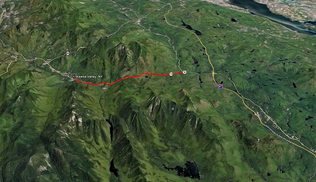
Route 73 from Exit 30 to Keene Valley is now open

Route 73, linking Keene Valley to the Northway (I-87) is now fully open. Initially only a single lane was planned to be open within 10 days, but the DOT, Governor Cuomo and private contractors put together an amazing feat and came out way ahead of schedule. Truly amazing based on the photos and descriptions of the level of destruction to Route 73.

Based on business numbers while the roadway was closed, it appears Route 73 truly is the lifeblood of Keene Valley. Business owners reported a 75% loss in business. However, this could also be attributed to the Adirondack Forest Preserve's; High Peaks Wilderness, Giant Mountain Wilderness and Dix Mountain Wilderness all being closed for much of that time. These happen to be 3 of the most popular wilderness areas in the park for 4 season recreation and contribute immensely to the local economies of surrounding hamlets. The Forest Preserve contributes over $1 billion yearly to the New York economy.

Full press release from Andrew Cuomo's office available here.

The red line on the map below outlines the section of Route 73 heavily damaged by Irene and now reopened to the driving public today. Good news, indeed, for leaf peepers, hikers, peak baggers, rock climbers and ultimately the business owners who benefit from the tremendous variety of recreational activities in America's premier weekend wilderness!

73 to KeeneValley

Friday, September 9, 2011

Scars of Irene on the Adirondack backcountry

This video is from the Adirondack Wild Center based in Tupper Lake, NY.

The aerial and ground based HD video is pretty compelling in both terms of destruction and the natural beauty of the Adirondacks. While watching it I couldn't help but be reminded why no matter where I am, I always seem to compare it to America's first wilderness -the Adirondacks.

Combined with the still images of the backcountry from the previous post, this should really start to put together the pieces of the puzzle that merely reading written reports left us unable to do.

Also of note, it appears this video was shot several days after the initial destruction, so things look pretty clean and orderly in the towns, in spite of the level of damage. Much of which was caused by relatively small streams jumping their banks. In Keene it was Gulf Brook, a stream that is less than 20ft wide most of the year, and that you can almost jump across in many sections just a few miles from Keene.

Those watching this from other parts of the country or world should be aware that the video covers a very small section of the New York State Forest Preserve, mainly the Eastern High Peaks Wilderness and surrounding towns. Though this is the most popular part of the Adirondacks, there are millions of acres that were largely unscathed from Irene, and also offer tremendous scenic beauty.