Showing posts with label High Peaks. Show all posts

Friday, March 13, 2026

Essex Chain’s deteriorating logging roads: Missed recreational opportunity in an Adirondack landscape long shaped by human activity

Essex Chain road surface


I am a wilderness advocate and am not in favor of roads being built or maintained in wilderness areas. While I don't necessarily believe bicycles are anathema to the wilderness experience, I am ok with them not being allowed on hiking trails in wilderness areas. With over half the Adirondack Forest Preserve being open to bicycles, there is plenty of space for everyone to have a slice of the pie. From a personal perspective, I am never about denying other user groups access. I am more for everyone respecting the access rights of other user groups and doing their part to make it all work. 


However, you absolutely can, even in wilderness areas, allow bicycle travel via linear recreation corridors or bicycle corridors (as they are implemented within the Catskills Forest Preserve). These corridors wouldn't necessarily be on hiking trails (in the Catskills some are and some aren't but they also go over mountains in the Catskills whereas you could route them on logging roads in the Adirondacks) and wouldn't infringe on anyone's wilderness experience. In a lot of wilderness areas these corridors actually already existed as logging roads. Wilderness is more a state of mind then a reality. Virtually no area of the Adirondacks is untrammeled by man. And no matter how we try to cover it up, the signs of man will always be there by those with a keen eye. So spiting recreationalist and also dividing them into worthy and unworthy user groups with the concept that their 2-10ft wide sliver of infrastructure (trails and logging/woods roads) is going to ruin the environment and wilderness experience, is simply gaslighting. It just gives groups an excuse to be recreational bigots. Like anything, if you give someone the moral high ground to justify exclusion, they will likely fight to stay on top of that hill. 


In the case of the Essex Chain, it's a low use area with a massive logging road infrastructure that could have been phenomenal for family bikepacking, canoe camping, and backpacking. Being a relatively small unit, especially without the proposed bridge over the Cedar River, it's not a place the more hard core recreational users will ever flock to. It's also difficult to get to and then into (especially if paddling). The upside, it came pre-built with all the infrastructure necessary for ideal recreation for equestrian, XC skiers, and the disabled.  Instead, through a series of compromises they made Essex Chain as unfriendly as possible for everyone. As a result the roads weren't intentionally rewilded and bikes were allowed to access them, but they were not longer maintained at all beyond the MAPWD section (which is in phenomenal shape, despite and in part motor vehicle use beyond it's locked gates) to Fifth Lake. In many areas, especially closer to the Cedar River, these roads are no longer followable at all. This was a huge loss in a place (the Adirondacks) where even cutting a standard 2-foot wide hiking trail requires years of studies and then approvals, followed by the inevitable years of legal battles. Imagine having trails already cut and then deciding to abandon them simply to achieve a made up ideal in an area massively trammeled by man but even with (minimal) road maintenance would have still mostly reverted to nature within the unit boundaries, aside from the linear recreational corridors.  


I understand there is very small subsegment of folks that believes that our wild lands should be completely undeveloped. I respect that. For the folks that despise recreational infrastructure, they simply can choose to avoid it. In total, recreational infrastructure probably occupies less than 5% of total forest preserve and easement land area. That means that the small subsegment that eschews infrastructure has unfettered access to 95% of the forest preserve. Lands we all pay taxes to keep. Lands that are for all residents to use. 


This post isn't arguing we build more trails (at least not without any oversight) bur rather that we maintain and redesign existing trail beds. Even if every feasible snowmobile trail in the Forest Preserve was hardened (this merely means avoiding or bridging swampy sections that are frozen in winter) and maintained for 4 season use, likely no additional trees would need to be cut. And in essence no new infrastructure would actually be built on untrammeled lands.


Hiking trail as wide as a road (photo: Adirondack Council)

Pragmatically looking at it on a grand scale those roads are about as insignificant as anything that could be done to develop the Adirondacks, but would have made a huge difference in dispersing use and helping to protect other areas from looking like tanks rolled through. It also would have made more of an economic difference to local communities whom tourism is at least somewhat important. 


When you look at the trails in the High Peaks Wilderness, you realize bikes and logging roads aren't the bad guy. You realize that without properly designed trails, hikers are just as destructive and capable of creating, merely with the soles of their boots, a path as wide as those logging roads that were incongruent with nature. A trail or roadbed is merely a linear recreational corridor that concentrates use, preventing the rest of the forest from being impacted. It's a sacrificial sliver of our public recreational lands. It's not the end of wilderness or the death of our environment. 


This hiking trail, which likely never
saw a bike, has nearly 3ft of erosion
(photo: Adirondack Council)


Hardened trail being built in the largest wilderness area in NY
and the east coast. This is actually the approved surface by the
most restrictive protection group in the Adirondacks.
It doesn't look very wild to me.
(photo: Protect the Adirondacks)


Tuesday, February 21, 2012

A postmortem to Winter 2012


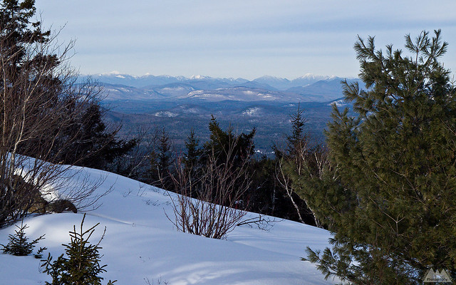
High Peaks from West Crane Mountain
January views of the High Peaks from the summit of West Crane Mountain. The photo is deceiving, as there was only about 7-12in of snow on the ground, much of which melted in the following days of warm rain.
 
March and April are historically the biggest snow months at elevation in the Northeast, and over the last few years winter hasn’t really stuck around until Presidents Day weekend, chiefly because of arctic highs forcing moisture snow) south into the coast and southern mountains. However, unlike this year, we’ve had a few false starts in those years. Plenty of snow, then a warm rainy spell with it's accompanying meltout. Enough that snowshoes and skis would have seen some justified use by Presidents Day, even if skiers and climbers weren't completely happy with conditions. 

This year, despite snow in the High Peaks and lower elevations right on schedule, it’s been pretty much shoulder season conditions since the start. It hasn’t been typical Northeast extremes keeping us in a state of perpetual November, just consistently mild weather. No record highs, but lots of 40 degree days with rain.

Looking at the climbing logs, it looks like it’s been a decent ice season for people putting up free climbs I couldn’t aid with a bolt gun. Some very ballsy and serious routes have gone up all over the Northeast. But Scottish mixed climbing has existed in conditions like this for decades across the pond, even if it is just now making a renaissance in the Northeast USA.

Skiers, on the other hand, haven’t had much to choose from. Unlike ice climbers, skiers -as a general rule- don’t get masochistic pleasure from finding the worst possible snow conditions and skiing.

While I’ve gotten a few trips out on ice, to date I haven’t actually needed my snowshoes. Granted, I haven’t needed them largely because lower elevation conditions are so poor I just haven’t wasted the fuel to get to the North Country’s 1000m+ elevations where snow can be found.  Uncharacteristically, I’ve yet to take a trip to Vermont or New Hampshire either. Often they have better conditions at various times of the winter. In the Adirondacks, above 2000ft there begins to be some sign snowshoes could be necessary, and I hear wonderful reports of snow upwards of 20-30 inches at 4000ft.

I haven’t really needed my winter gear at all. It’s been mild enough most days that I’ve worn my base layers and soft shell pants. Other than wearing my insulated boots because they are required for ice climbing/steep crampon terrain, I haven’t needed those either.

The lack of snow also has meant my camping gear has pretty much been mothballed. I love snow camping and winter backpacking. Pound out a perfectly flat tent pad where ever you choose, and sleep like a king in the quietness of a forest sound proofed by fresh snow. Camping on the solid sheets of ice that has replaced snow cover or the forest floor is a lot less fun.

Crampons, or rather the necessity of crampons, are a completely different story. These are standard gear from car to summit and back during 2012. Even in the Southern Adirondacks, where there was almost no snow at all on Super Bowl Sunday, we needed crampons the entire two miles back to the car, hiking on a moderately graded low elevation trail.

The most depressing fact is that looking at the NOAA CPC long range data, I can’t say I am particularly optimistic winter is going to start anytime soon. NOAA says that we will continue with above average temps into April, along with normal precipitation. Neither of these factors scream big snow systems or extended cold.

No doubt we’ll get a blizzard in April to muck up spring hiking and rock climbing season. Other than that, I don’t see our recently historic trend of 8 grand weeks of winter beginning in late February.

I suppose the silver lining is I didn’t fork out $220 on those Tubbs Flex Alps I’ve been eyeing since last winter. Maybe I’ll score a used pair over the summer for a bargain price. I’ve also driven 75% less than a typical winter, which is good for the wallet, good for the odometer, and good for the environment.

All that said, I like living in this part of the country because of our four “over rated” seasons -as Left Coasters and Gulf Coasters like to put it. So no matter what the benefits, it still sucks to completely miss out on the most unique of those seasons.

Winter 2012, you had so much potential, but you never really stood a chance in this cruel world!

Monday, September 12, 2011

Route 73 from Exit 30 to Keene Valley is now open

Route 73, linking Keene Valley to the Northway (I-87) is now fully open. Initially only a single lane was planned to be open within 10 days, but the DOT, Governor Cuomo and private contractors put together an amazing feat and came out way ahead of schedule. Truly amazing based on the photos and descriptions of the level of destruction to Route 73.

Based on business numbers while the roadway was closed, it appears Route 73 truly is the lifeblood of Keene Valley. Business owners reported a 75% loss in business. However, this could also be attributed to the Adirondack Forest Preserve's; High Peaks Wilderness, Giant Mountain Wilderness and Dix Mountain Wilderness all being closed for much of that time. These happen to be 3 of the most popular wilderness areas in the park for 4 season recreation and contribute immensely to the local economies of surrounding hamlets. The Forest Preserve contributes over $1 billion yearly to the New York economy.

Full press release from Andrew Cuomo's office available here.

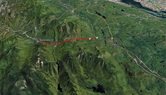
The red line on the map below outlines the section of Route 73 heavily damaged by Irene and now reopened to the driving public today. Good news, indeed, for leaf peepers, hikers, peak baggers, rock climbers and ultimately the business owners who benefit from the tremendous variety of recreational activities in America's premier weekend wilderness!

73 to KeeneValley

Friday, September 9, 2011

Scars of Irene on the Adirondack backcountry

This video is from the Adirondack Wild Center based in Tupper Lake, NY.

The aerial and ground based HD video is pretty compelling in both terms of destruction and the natural beauty of the Adirondacks. While watching it I couldn't help but be reminded why no matter where I am, I always seem to compare it to America's first wilderness -the Adirondacks.

Combined with the still images of the backcountry from the previous post, this should really start to put together the pieces of the puzzle that merely reading written reports left us unable to do.

Also of note, it appears this video was shot several days after the initial destruction, so things look pretty clean and orderly in the towns, in spite of the level of damage. Much of which was caused by relatively small streams jumping their banks. In Keene it was Gulf Brook, a stream that is less than 20ft wide most of the year, and that you can almost jump across in many sections just a few miles from Keene.

Those watching this from other parts of the country or world should be aware that the video covers a very small section of the New York State Forest Preserve, mainly the Eastern High Peaks Wilderness and surrounding towns. Though this is the most popular part of the Adirondacks, there are millions of acres that were largely unscathed from Irene, and also offer tremendous scenic beauty.

Thursday, September 8, 2011

Images of the the aftermath of hurricane Irene on the Adirondack High Peaks and John's Brook Valley

I highly advise anyone with some backcountry aspirations to take a look at the destruction -and in some ways, improvements- to the Adirondack backcountry as seen through the lens of Brendan Wiltse.

Some great photographs of the damage in an area not yet open to the hiking public: Hurricane Irene damage to the Adirondack High Peaks, John's Brook Valley Region, including several new slides along existing trails.

I say improvements because anyone that has hiked the Orebed trail will certainly appreciate it is no longer a steep, slick, slabby tree tunnel, but it now has some views and the trail is more like a true slide climb than an eroded hiking path. I always hated that trail, even more so when the ladders were missing this spring and early summer. Sadly, the Adirondack Mountain Club Pro trail crew was putting in new ladders just before the storm. Much of their work destroyed and mixed in with rubble from the slides.

Oddly, while a lot of damage was also done to lowland approach trails that is not good, the potential new routes up slides, and the opening up of the terrain on existing trails actually looks like it is a long term benefit. It will be interesting to see first hand just how different the views are off the mountains of the Adirondacks.

Also from Brendan's blog:

Friday, July 15, 2011

Don't Build Your House At The Bottom Of A Mountain.

All this really shouldn't be surprising to anyone. First, it's well known the Adirondacks have generally poor soil. Second, it's well known the Adirondacks have thin soil that is prone to "slides" following excessive rain or snowmelt, look around at the scenery, all those bare 2000ft rock slides came from somewhere.

My layman's take on this, it's a lot like when you get several types of snowfall in a short period of time. The different layers CANNOT bond together, thus they are more prone to creating an avalanche. These slides in Keene Valley are essentially dirt avalanches. And this particular slide is from multiple types of dirt, in different layers, unable to bond.

I guess I don't understand why people feel the need to tempt fate with selecting a home location. For example, when you build your house on the coast of the Outer Banks North Carolina, you have to expect it's going to get hit by at least one hurricane per year, if not several. Eventually, erosion, winds and flooding will destroy the house, one way or another. When it comes to mountains, just take a look around the base of them. They are filled with big piles of rocks, rubble and dirt that used to be somewhere closer to the top.Where is New Hampshire's "Old Man" of the mountains today? Despite being epoxied and wired into the mountain, he eventually succumbed to the forces of gravity and weather, and is now just a pile of rocks at the base of a mountain.

In spite of all our technology, we cannot defeat the forces of nature. Some disasters are just random acts of mother nature, but many others are people intentionally tempting fate.


From the ADK Daily Enterprise:


But what happened to the Adirondacks during the last ice age laid the groundwork for the landslide. Kozlowski said glacial ice advanced south into New York and then retreated at least 20 times. Water was often trapped in front of the glaciers, forming large, deep lakes where clay and silts were deposited.

"As we've been looking around over the past month-and-a-half, we're finding glacial lake sediments at elevations at 2,000 feet and higher on the sides of the High Peaks," he said. "This was not recognized prior to this."  - Adirondack Daily Enterprise