 |
| Traversing across the upper section of the lower slabs of Whiteface Ski Slide #3. |
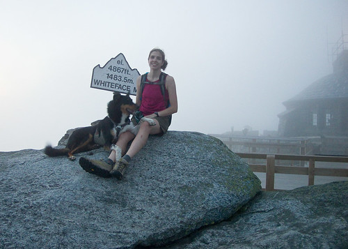
I once staked my own path to a Christian heaven arguing the absurdity that animals couldn't go to heaven. Because my confirmation teacher was unable to provide any meaningful proof he was more in the know than my own principles, it actually led to me dropping out of confirmation before my 3rd and final year. Anyone can make up a story, and in mine, dogs do go to heaven, and if not, they just become worm food like you and I!
So if I was correct so many years ago, Caney was looking down on us Saturday with a big smile on his face, saying, "how do you like those slabs now." Karma is a cruel bitch, especially when you blindly question the commitment and effort of those who have done what you have not.
A few months ago, George questioned how tough climbing a 5th class slab really could be. "What does it mean to climb a slab", "If a dog could do it, it can't really be climbing," -can it? "Dogs can't actually rock climb." As if rock climbing only involved the vertical pieces of plastic and gri-gri's found in your local gym! Of course it burned me up, mainly because till that point (and till this day) George had never climbed a harder route than Caney. It also burned me because that dog logged more vertical with me than any two humans combined and never put me at risk once, never quit on me, and always impressed me. Even days before he died of cancer that had spread to his spine, he left me thinking how could a cute little 50lb fur ball possibly be that insanely tough. Add in the fact George didn't really understand what exposure was and how it changed everything about a climb, and I was starting to steam on the summit of Slide Mountain on that May Day.
Caney had freakish technique coupled with the arrogance (confidence) of an elite climber, but he also had no fear of heights, exposure didn't scare him. It made no difference to him if we were 10 feet off the deck or 1000ft. It was climbing and nothing more. So, it was ironic that on Friday morning as I started to pull away for the Adirondacks, I went back into the house and grabbed my dog tag that memorializes the best trail canine ever, and Saturday was for him!
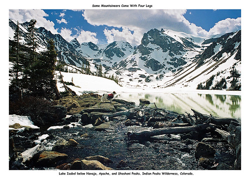 |
| Caney before we entered the IPW and spent several days climbing and descending the glaciated peaks in the background. |
What plans...
We spent about 3 months planning for the Trap Dike with a MacIntyre Range traverse. A really solid day that bagged five 4000ft peaks, and had Great Range like elevation changes, mixed with semi technical climbing. If you are going to put it all out for a single day of hiking, that would be the trip I'd do!
Then Irene came, the High Peaks closed, roads closed, the Trap Dike and Colden were among the many slides that grew or were entirely new in the Adirondacks.
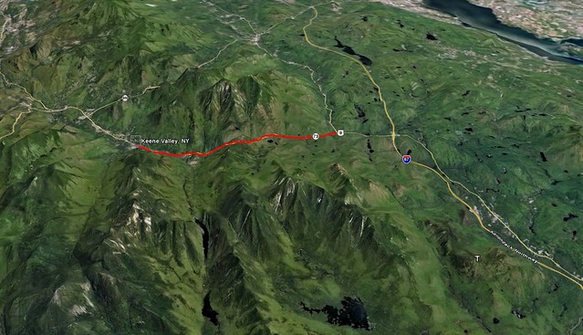
Much meticulous planning down the drain. Still, my partners wanted to do something "technical" or as they put it, "the more technical the better." With Giant and Dix Wilderness closed as well, my eyes turned to Whiteface.
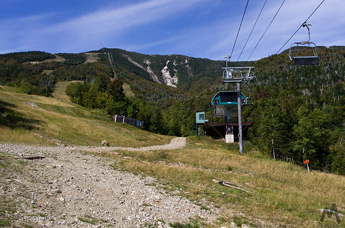 |
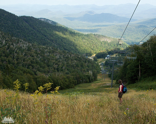
| Slides and summit from the ski slopes. |
Though, I personally thought the Dix Range and Macomb Slide was perfect for slide climbing virgins, Whiteface was open for business immediately. To me, it made more sense to plan for the most likely definitive option. Besides, with the exception of Ski Slide #1, most of the slides are rarely climbed. We’d be doing something that not a lot of people do very often, a real adventure. So while I was certain that the Dix and Giant Ranges would open shortly, I decided the bigger adventure would be Whiteface!
Men don’t do 2nd class slides...
 |
| Proudly displaying our redesigned grill. |
Ironically, while gearing up at the Whiteface Ski Center parking lot, a group of 3 or 4 guys asked us what the easiest slide was. I commented the far left side, Slide #1, is the one you want, but mumbled under my breath (jokingly) that real men don’t do 2nd class slides. John and George laughed with me!
Aim, Colvin and I checked out Whiteface Ski Slide #1 on a recon mission a few weeks ago. Ski Slide #1 was definitely not "technical." It was mostly Class 2 climbing, with cruxes in the 3 range depending on your route selection. Even accounting for the fact we were climbing it just days after Irene dumped up to 8 inches of rain, the wetness just made it a little more scary, but not significantly more difficult. For the purposes of our more technical trip, it didn't fit the description of what my group was looking for. Slide #1 is perfect for dogs, and girls with a fear of exposure, but not a real adventure in the mountains for 3 grown men.
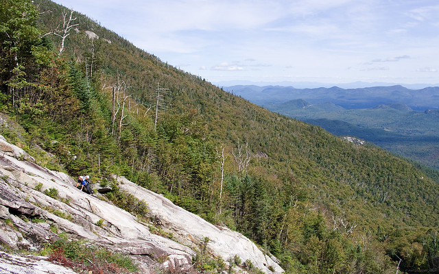
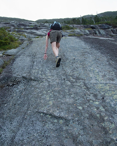
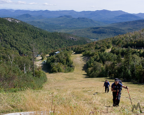 |
| Ski slope ascent. |
The best laid schemes of mice and men...
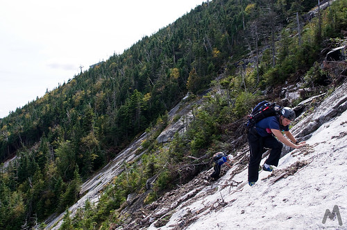
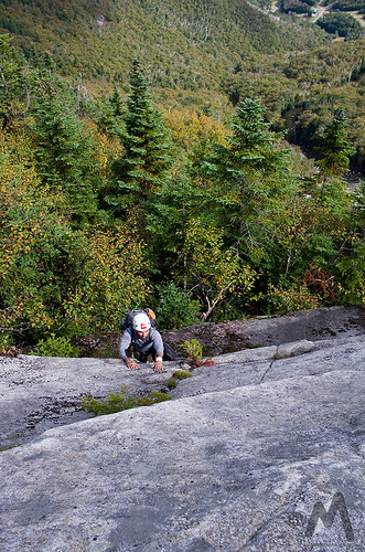
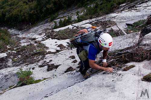
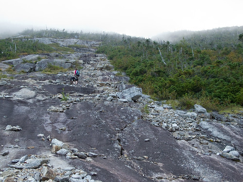
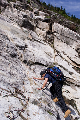 |
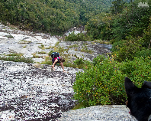
| Ascending the lower slabs. |
After careful planning everyone was on board, the trip was thoroughly planned, and the route exactly as expected.
Whenever I plan a trip with people that are unfamiliar with the terrain, region or technical difficulties, I try to be as explicit as possible. Though not all the trips go as planned, very rarely do we come across a situation that wasn't thoroughly covered and re-covered. The preferred goal is to be self sufficient when I'm in the mountains. Even a well prepared trip can have a serious accident requiring rescue, but starting out behind the curve is just reckless; putting everyone, including rescuers, at risk for no reason.
Even the band must face the music...
 |
| Ascending the lower slabs. |
The moral is be careful what you wish for. While still low on the slide and solidly on the 2nd class terrain the chatter became, "how much steeper does it get." Or, "is there a secondary way around it."
Since the goal of the trip was technical slides, I actually never considered any other option but technical slides, and was prepared for anything that involved the slides, including bailing and rapping to the bottom if need be. I definitely wasn't bushwhacking to the top though!
As far as the difficulty of slide #3, I'm quite certain with the right partner and top rope belays, I could have gotten my dog, Colvin, to the top of the slide. He isn't the climber Caney was, but he will climb hard when on belay. So, without question, it was definitely climbable by humans wearing sticky rubber shoes!
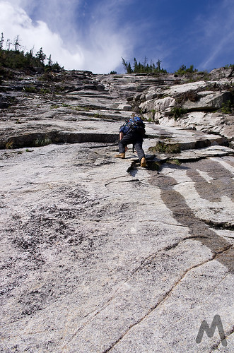
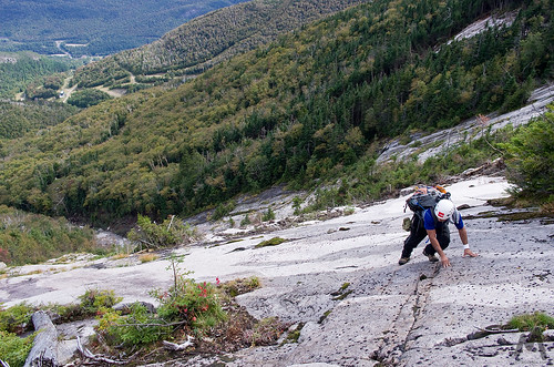
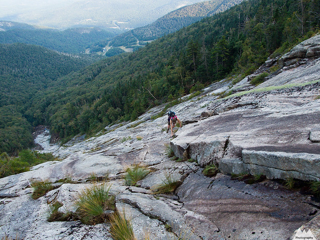
 |
| Ascending the upper section of the lower slabs. |
Committing to exposure...
The problem, of course, is exposure. It separates climbers from non climbers. Making a few 3rd, 4th or even 5th class moves with the comfort of a 10 foot drop to flat ground is not very committing, but when you are looking down at 100ft run out falls, followed by a band of tightly packed spruce trees waiting to rip you to shreds and then 100 more feet of 60* slide below that, things change really fast. Basically, when you are looking at death or serious injury, the description of 2nd, 3rd or 4th class in a book becomes entirely irrelevant for that moment. Commitment is everything in climbing, and I've personally shit my pants plenty of times before either committing to a crux move or bailing and handing it off to my partner.
I'm not, at all, making fun of my partners, the slides were wet and slimy in places (expected) and much of the 2nd and 3rd class climbing was polished rock (also expected, and the reason for rock shoes). But the steepest climbing, the class 4 terrain, was actually pleasant. Other than the pine needles interfering with grip at the edges, the rock was grippy and dry going up the center. If I didn't have to fix the lines to the trees, I think the 4th class climbing was not only the most fun section, but also the safest. Unfortunately, I had to move to the edges to fix the rope, which made exiting back to the slide a bit dangerous for me.
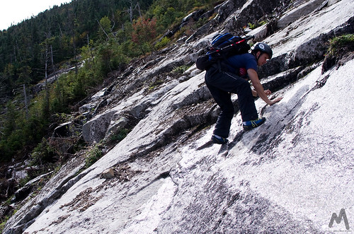
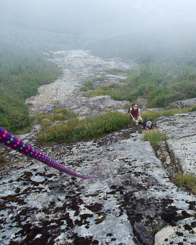
 |
| George traversing across the exposed wet lower slab on Slide #3. |
Raybrook, we have a problem...
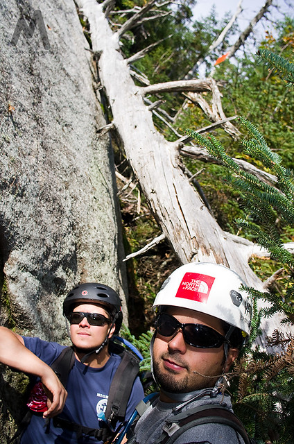 |
| John and George below crux pitches of #3. |
Being what I thought was over prepared, we avoided a rescue situation, in spite of rescue being, briefly, a serious topic of conversation. One partner, John, wanted off the slab ASAP and decided to bushwhack 600ft through the band of trees in between Slide #3 and Slide #4. That in itself was a hell of an endeavor. Kinda like choosing death by 1000 slices over a single bullet to the head. Me, personally, I’m taking the bullet and sticking to the rock. There was no discussion, he made a beeline for the trees and we didn't see him till the summit.
George also wanted no part of the 4th class slabs, but I was able to get him to finish the slab, rather than take a steep and dangerous 'whack through the trees on 60* slopes. George was pretty sketched after a 10ft slide down some very steep terrain as he -also planning to leave me for dead on the slide- attempted to get to the tree band between slides #3 and #4. He did everything right during the slide downward, and didn't get too scraped up as a result. I then got him to traverse over to the crux pitch via a Prusik and a fixed line.
Once at the base of the crux pitch there was a small ledge for us to change to rock shoes. In hindsight, we changed to rock shoes 50ft above where were should have, and that probably was a factor in George’s uncontrolled descent. We used the ledge to re-organize our gear, have a snack and mentally regroup. He was pretty shaken up, so we took a sizable break.
George was cramping, probably from a combination of nerves, dehydration and lack of electrolytes. He was actually cramping so bad he couldn’t tie his rock shoes himself. I don’t think he was eating much on the slide, so I gave him an electrolyte tab for the cramps as we discussed the options of ascent or descent.
Once we were rested, I was certain George could get up this with the help of the ropes and rock shoes. Traversing across to Ski Slide #1 was foolish, rapping was equally foolish, more so since I'd have to lower him or counter rappel and then we’d still have a long miserable walk down the ski slopes.
 |
| George on a headwall. |
Unfortunately, the day of cragging I'd planned for Friday didn't happen, so we were a bit behind the curve with climbing and descending techniques. This definitely didn’t help matters. Had we descended, the down climbing on the first pitches was easy enough, but down climbing always seems harder. To me, the best option remained to finish the climb.
By the time we were done with the break, John had made it either to the summit or at least off the slabs via his long bushwhack. In either case he was calling down to us, and we were calling back to him. Apparently the second group on Ski Slide #1 felt we were in trouble, and subsequently left a note on my car noting (incorrectly) that they saw us on Slide #2 and to call them before dark...or else!
I’ve always noted that climbers and mountaineers tend to be very considerate, often without question sacrificing their own trip, their gear, and their own safety to help other people in need. Though I was a little curious as to why they thought we were in trouble, I appreciated the sentiment. John did give them a call back when we were on our way to Lake Placid for dinner.
With George and I still on the slide, the crux pitch -the 4th class terrain- was about 80-120ft of 60+ ० open slab. Starting to trust the gear, techniques and rope system, George eventually calmed down. After two rope lengths of fixed lines, he was able climb above the rope on his own, all while still on the open -runout- 4th class terrain.
I never intended for him to climb above the anchor on the static rope and Prusik, which I was using purely as a fixed line for ascent from below. Nor did I think he would decide to do that. And it was this section, on this setup, that I was actually most concerned for his safety were he to fall. The problem was, once he started out, I wasn't about to explain to him the issues with static ropes and high fall factors, assuming, of course, the Prusik didn't burn through. When you have a rope and you trust it, sometimes it's enough to calm you down to be able to make the moves you need to.
At the top of this pitch, George set up a fixed line for me since I wasn’t too keen on traversing out away from the several feet of pine needle covered slab. Unfortunately, I did not have another Prusik, and the Kleimheist, which I have probably never used in actual climbing, just wasn’t coming out correctly. I later realized the mistake I was making. Regardless, once above the needles the rope became unnecessary and the slab was nice and grippy.
This was the last section which we used the rope, and eventually made it up the remainder of the head wall to the top of the climb. The climbing again got wet and dirty, but also less steep. A few minutes later we had to contend with the heinous bushwhack to the top.
 |
| George on old Ski Slide #3. John and I climbed the new Spring 2011 widened section to the left. |
It’s a love hate relationship...
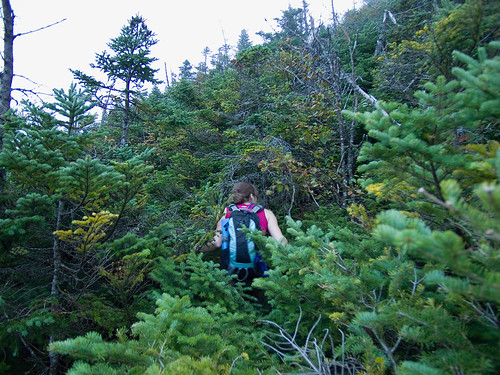
Had we been able to traverse to Ski Slide #4 as originally planned and climb it's crux, we only had a short bushwhack to the summit trail. From the top of #3 we had at least 200 vertical feet of steep 'whacking. Two sections were vertical for me, including a vertical wall of moss cleverly disguised as rock, though my partner managed to find ways around them. It seems John also found this camouflaged wall of death, as he confirmed my description of it, and I saw recent footprints while ascending it. It took us about 30 minutes to climb that final 200ft, in comparison, the top of Slide #1 to the summit was a mere 10 minutes.
Though it’s the case on every bushwhack, this one seemed especially rough. The very trees we needed to pull ourselves over mud and moss covered rock slabs were also trying to rip us apart.
 |
| Little bushwhack between slab sections. Nothing like the final bushwhack to the summit. |
I went left, up the steepest of the slabs/walls. It was an easy 3rd class zig-zag that got me out of the trees and onto drier rock. George when right, and ended up on the trail a few feet to the north. Climb complete!
Final verdict...
 |
| George on the lower slabs with another group below. |
I personally had a great time. Though, as usual, the trip didn’t go as planned, 2 of us did climb Ski Slide #3. We can put that in the books as a success. I just have #2 and #4 to knock out. We didn’t descend the Lake Placid/Whiteface Brook Slide as planned. Apparently slides are a lot tougher than they appear, and neither of my partners had any desire to revisit one so soon. I didn’t argue much with the group decision to skip the LP Slide descent. I was fine with the 2 mile longer hike out and a bit more of a workout. Plus, while the LP Slide would have given us 30 minutes more of light, we were still bushwhacking in the dark. I’d prefer to just stick to the trail than lose an eye on a night ‘whack.
 |
| John on Whiteface |
I let the guys take off ahead on the descent because, apparently, I have some issues with falling when I’m keeping ahead or keeping up on descents. After two spills, I gave them a 5 minute lead and met up at the bottom of the descent, about a half mile from the lean-to. I was surprised they were only two minutes ahead of me, and yet I hadn’t fallen once in the 2 miles they hiked in front of me. Within two minutes of catching them, I fell into waist deep ditch, which I threw myself out of and then hopped, skipped, crawled, rolled and flew 20ft down the nearly level trail till I could regain my balance. Fortunately it was the last of that.
After filtering water at the lean-to, it was a non stop trip to the car.
Once we got back to the flat or rolling terrain that is the Connery Pond/Whiteface Landing trail, John and I started alternating between jogging and speed hiking. We ended up averaging a little over 4.5mph for the last 3 miles. I estimated my pack was at 25-30lbs so I was happy with the pace. My body agreed Monday morning after repeating the loaded pack run up and down Lake Road to Ausable Lakes.
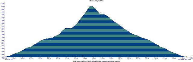
Back at the car, 10 miles, 7500ft vertical feet and 11 hours later, we were primarily concerned with dinner. Lake Placid Pub and Brewery was out, and Wise Guy’s in Lake Placid was in for a well earned burger and beer!
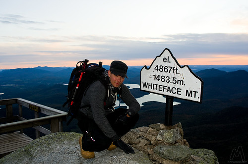
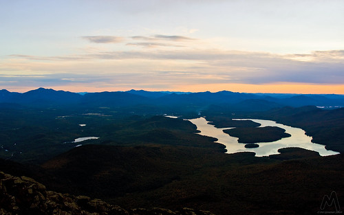 |
| Sunset over Lake Placid from Whiteface Mountain. |
Lessons learned...
1. It’s been a wet summer, and a wet few weeks. I would personally avoid the Whiteface Ski Slides in summers like this. This is the sort of endeavor best suited for a drought year like the summer of 2007.
2. Known but reinforced. You are only as strong as the weakest member of your group. Always plan around that. Never underestimate the challenge based on your least experienced members comfort level.
3. I would not recommend climbing a runout 3rd or any 4th class climb with exposure without first spending at least a day outdoor rock climbing. You can work on basic skills and techniques far better in the controlled environment of a rock crag than 600ft off the deck. Obviously, climbing on a top rope isn’t the same as soloing exposed 4th class terrain, but it is something to help put perspective on your climb.
4. Starting out over-prepared sometimes means you end up plain old prepared. Self sufficiency is a cornerstone of mountaineering and should always be the primary goal. I actually didn’t expect to be in the situation we were almost in, but I did think about it as a worst case scenario. In the end, it saved us a call to Ray Brook for DEC assistance off the mountain.
5. While rock shoes could certainly be justified for the crux pitches, I’m inclined to think a good pair of sticky rubbered approach shoes could be better provided you are experienced at climbing slabs and slides. This is because you often travel between wet moss and mud, followed by dry steep rock slabs. Switching shoes is impractical, but often a rock shoe isn’t right or a boot isn’t right for the terrain.
6. Do not underestimate slabs/slides. Unlike vertical or overhanging rock, they tend to not discriminate based on the climbers BMI (fat factor), but they require complete and total trust in your sticky rubber shoes and footwork. No pulling jugs, no false sense of security as you strong arm your way up. They are in a sense the perfect starting point for technical climbing, as they force novice climbers to realize how important the feet are in ascent. Climbing is often thought of as a world of upper body strength, but the reality is good footwork is the foundation to all
7. Exposure changes the game. A lot of trails in the High Peaks have similarly steep slabs but with only a 10 or 20ft fall potential. Looking down at 100-400ft or more of unbroken fall is a game changer in terms of mentally conquering the climb. Anyone planning a slab or slide climb should really consider their own tolerance for exposure before committing to a long climb.
8. Rock shoes, helmets and ropes. Whiteface Slides are steep enough that knocking rock loose could be a problem, however, the helmets actually helped with the bushwhack. Necessary? Debatable, but probably not overkill if your group isn't being careful to check for loose rock. Rock shoes (or sticky approach shoes) on the other hand were pretty much a requirement. The slides are seemingly polished, and the extra traction is never a bad thing. Ropes and harnesses, and the ability to use them can keep things from getting out of control.
Slideshow of additional images from the 2011 slide climbs on Whiteface Mountain. All images with Pentax K-5 DSLR and DA 21mm Limited or FA 43mm Limited lenses.


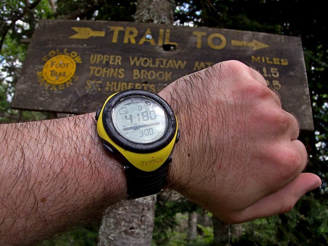

 My only gripe with the black version I got, is that the brushed metal does show scratches quite easily. As a matter of fact, I scratched the metal pulling on plastic at the climbing gym, something I never would have expected. The glass face, however, seems as scratch resistant as my Seiko, which has taken quite a few direct hits over the years. If you are concerned about scratching it up, I’d recommend the silver versions, which should hide minor scratches a lot better than the black version.
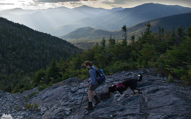


