Showing posts with label Round Lake. Show all posts

Monday, September 10, 2007

ADK Canoe Traverse By The #'s

Back from 10 days in the Adirondack backcountry. 10 days without a road, power line, motorized vehicle, and aside from 2 cameras and a GPS (most useless/unused item I carried as usual) any electronic devices, or contact with the outside world.

This trip really let us get intimate with the Forest Preserve. While much of the land wasn't true virgin wilderness, it was beautiful, fairly pristine, and at the end of the day, wild, public, and remote enough to make you feel like you accomplished something while going somewhere. Sure some might be disheartened by clear cuts and logging roads, but try portaging through a Walmart, and then rethink your disdain for the lumber industry who owns a considerable portion of the 40% of private land in the Forest Preserves 6 million acres.

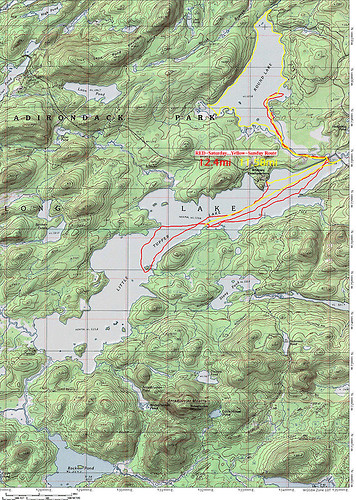
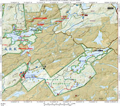
I attached a map of this trip, it's a general map but even with the latest Topo Software the rate at which land is acquired and added to the forest preserve the maps are just inaccurate. All the land we traveled through is legally fully state land, and the route is more accurate than the various trails on the ADK Topo Map 3D CDs which were just released a few months ago. Many logging roads are missing, and many that are shown on the maps don't exist anymore (if ever). While the USGS perhaps did the finest cartography of any nations lands, it simply fell behind over the last 50 years and most topo maps are borderline useless and hopelessly outdated.

On the map below red dashes are portages, solid red is hiking, blue dashes are paddling. Anytime you see a solid red between bodies of water it was a portage, however, we might have hiked it on an off day or it just blended together and looks solid. All the portages were "double carries".
For non paddlers that means 1 trip with gear, return to start, get more gear/boat, and back to the next leg. basically, each portage/carry is x 3. To do single carries means a super light boat, well established smooth trails, and a short supply of gear (aka, "light is right" philosophy); we had none of the former, so we doubled. No shame in working hard, and far better than sitting home and wondering what could have been done with a lighter boat and fewer carries.


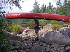
I have to thank Eric from KnuPack Systems. Simply put, carrying a 75lb boat was almost fun with his portage system (and I'm almost completely serious). I used an old Kelty Super Tioga that I bought for $5 and added his $45 retrofit kit. It didn't fit, nor was it guaranteed to, but with some last minute sanding I got it to fit. The bottom line, best $50 I ever spent. After a few hiccups, I actually preferred carrying the boat to the dry bags. Those still using yokes, or portage carts (absolutely no way a cart would work on the trails we did) need to get a KnuPac kit. Controlling the boat with a big external frame and some tag lines with the weight on your hips is amazing. It's like being a puppeteer. I actually beat Aim by 2 minutes on the Lily Pad Pond-Shingle Shanty portage, one of the roughest on the trip. the boat simply cleared a path thought the forest and I just followed it (ok sounds easy, but not really that easy). 5.5 total miles of carrying 80lbs (2 lbs of ballast on the stern +3lbs for the frame) and not a single back or neck ache once everything was fully adjusted.
Of course a full detailed trip report with photos will follow at some point in the near future.....
BY THE #'S
  • 10 total days
  • 73.33 total miles traveled (hiked, paddled, portaged)
  • 16.12 miles portaged/carried (no you didn't misread this, we did carry 150+lbs of gear, including a 75lb 16foot boat 16.12 miles over rough terrain on NOT yet established trails)
  • 6.88 miles of various hiking including (former) logging road exploration, former great camps, abandoned train stations, view points, summits, etc

  • 1 the amount of times the boat drifted away while not tied/removed from the water (hey the takeout was rocky/bouldery and rough, and it was a protected area so we figured it would be fine for a few minutes)
  • 100m the distance I had to swim to get the boat
  • 9 days of fair weather
  • 1 day of rain
  • 8 wind days (white caps on the lakes)
  • 90+ liters of water Aim filtered
  • 3000 meters swam (swam just about every day, and generally not to chase runaway boats)
  • 0 active roads seen or crossed
  • 0 motorized vehicles seen/heard in 8 of 10 days (day 10 saw a float plane land on Lows 2 X, heard logging while on Clear)
  • 4 rest days/ 0 mile days (not exactly true, we paddled, swam or hiked each and every day but stayed 2 nights at the same camp on rest days)
  • 6 travel days
  • 5000 saw strokes (okay, I have no idea, but I cut a lot of wood, including some on the portage "trails")
  • 1 leech bite (over 10 days this is an amazingly low #)
  • 2 the amount of hours it took me to realize the leech was on me
  • 2 the amount of hours it took to stop profusely bleeding after I removed it (there was blood pooling in the bottom of the boat that I had to sponge out)
  • 5 blisters
  • 50+ cuts (per person) from briers, thorns, branches, entire trees, and assorted trail debris
  • 1 perplexed look on the rangers face day 1 when we informed him of our plans while sitting on the rocks by our campsite getting some sun (hey, I understand, I look like a meatball and Aim like a string bean, neither like we could carry enough or move far enough to complete this trip)
  • 1 relaxed look when that ranger realized we had fully researched our plan and we're aware of the difficulty
  • 1 perplexed look on my face when the ranger said "yeah, someone flagged the trail to Harrington but we don't know who?" Huh? isn't that the DEC's (rangers) job?
  • 1 hour of paddling head on into 2 foot swells on lows lake with a 10-15mph head wind the lake literally looked like class III whitewater as we paddled into it
  • 3 # of officially marked portages
  • 9 # of total portages
  • 0 people seen on our portages
  • 0 people seen on interior lakes that required portaging
  • 4 # of touring kayaks we beat from Grass Pond on the 12 mile trip out Sunday morning into a slight head wind and pouring rain with a loaded open high volume tripping canoe!!!
  • 4:15 min time is took to paddle 12 miles and portage .53miles (total) from Grass Pond to Hitchins.
  • 1 # of chipmunks I was forced to kill because people fed them (a fed animal is a dead animal)
  • 1? # of chipmunks that broke into my parked car, ate all the sunflower seeds, pooped on the seats, ate gum, rummaged through the glove compartment, and slept in the backseat for several days!!!
  • 110 percent satisfaction of the efficiency we got everything done on travel days
  • 10/10 fun factor on this trip!!!


technorati tags:, , , , , , , , , , , , , , , , , , , , , , , , , , , , , , , , , , , , , , , , , , , , , , , , ,

Blogged with Flock

Tuesday, August 14, 2007

The Whitney Wilderness

“I date from Little Tupper Lake, and a finer lake it would be hard to find. No desolate lines ofdrowned lands here. All as it came from the hands of nature. Have been out this morning deer hunting, so to speak. Laid off for four mortal hours waiting for a deer to attempt the crossing of Dukett’s Bay. No deer came. But there came a loon, and he settled within ten rods of the canoe, raised himself on hind legs (they are very hind, and he has no others), turned his white, clean breast to me and gave me his best weird, strange song. Clearer than a clarion, sweeter than a flute, load enough to e heard for miles...”

From Nessmuk’s Adirondack letters
Cruise of the Sairy Gamp, 6
Forest and Stream, Sept. 13, 1883


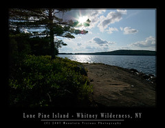
Acquired by the state in 1998-1999, Aim, Caney, and I were among the first legal public paddlers to use Little Tupper Lake and the Whitney Canoe Area in the summer of 1999. It wasn't in a guide book yet, and there was little info, we just happened to drive by the headquarters while going to Lake Lila.

I'd venture to say, over the years, we've logged more nautical miles in the Whitney Canoe Area than anywhere else in the park. Probably in excess of 200 miles. I'd further be willing to bet that every mile on Little Tupper is worth 1.5 miles on any other regularly paddled lake. The wind seems to blow southwest in the morning but in the evening (just in time for the paddle out) it seems to come from the east. I'm guessing this phenomenon is more than just bad luck. Most likely the wind is being generated by adiabatic cooling off the summits of the high peaks after the sun gets low on the horizon.

This weekend we added another 25 miles of paddling to our Whitney Wilderness odometer. In typical fashion we were the first ones in Saturday morning, and the last out after dark Sunday night. Headlamps safely packed in the dry bags we had no choice but to paddle in the dark on a moonless night.

Formerly part of Whitney Park, owned by the Whitney's (of Mary Lou Whitney socialite fame), Gov. Pataki acquired this well logged but fairly pristine tract of land using funds from the Environmental Protection Fund and Clean Water Clean Air Bond Act.

The Whitney's still have a presence in the William C. Whitney Wilderness that is more than the legacy of a name. They own the only two private residences in the wilderness. Camp On The Point, and Camp Francis. They also still own extensive tracts of land forming the southern border of the Whitney Wilderness which comprises the rest of Whitney Park.

In terms of land acquisitions this is about as big as it gets. The Whitney area was logged, lightly mined and has a (unimproved) logging road system, but is essentially pristine in nature.

It supports multiple types of recreation, including skiing, paddling, hiking and horseback riding. As a wilderness, it is motorless, and mountain bikes are also prohibited.


The Whitney Wilderness is so pristine in fact, that Little Tupper Lake is one of the last bodies of water in the northeastern US to retain it's original native trout population. It's an example to me, and hopefully to others, how logged land is far better than paved land with a mini mall on it. Left alone in 20 years only the astute hiker or paddler could tell the difference between land that was logged in a environmentally conscious fashion and native forest. In 50-100 years even they might have a hard time determining just how wild the land was when it was acquired. Those sandy hard packed and shadeless logging roads have a constant tendency to grow in and become the most pleasant grassy woods roads.

All the bodies of water in the WWW are natural and free of man made impoundments. The only dam within the wilderness is located at the Round Lake/Round Lake Stream outlet, and it only serves to raise the water level a maximum of 2-3 feet.

In itself the Whitney Area is an impressive acquisition but when combined with adjoining state lands the magnitude of this purchase really begins to take hold.

The Whitney Canoe Area adjoins Like Lila Primitive area, and as of 2007 also links to Bog Lake, Clear Pond, and the Oswegatchie via Lake Lila. This essentially opens up multi-day wilderness traverses within this part of the park and makes it far more than the weekend paddlers paradise it has been for many years.

It's now possible to travel for 40-80 miles in several directions with a few short portages. Linking rivers, lakes, ponds and streams, there are numerous options for long distance paddles. And with the exception of the Beaver River, all on Forest Preserve land, or lands with easements.

In 2001 the state began negotiations to purchase the Round Lake Tract from International Paper. Round Lake, a largely a undeveloped wilderness lake, adjoins Little Tupper Lake via a large navigable outlet.

The shoreline of Round Lake was leased from IP to various hunting clubs, but other than some dirt woods roads, and some old razed and largely removed hunting camps it is essentially undeveloped and primitive in nature.

While I'm not entirely sure when it became legal to paddle Round Lake (in 2004 the state still advised against it) this weekend was our first trip to Round Lake. With it's undeveloped irregular shoreline it is a great addition to the Whitney Wilderness. Furthermore, it adds a connection to Tupper Lake and the Bog River from the east via a technical whitewater paddle down the outlet to the Bog River.

Round Lake itself is about 1/3 the size of the 6 mile Little Tupper Lake but the shape and irregularity of the lake and the outlet offer quite a bit of paddling. Like Little Tupper, Round Lakes orientation and shape make it prone to wind. The lake is longest in a southwest direction and gets hit with the same winds as Little Tupper.

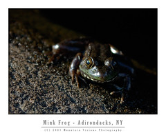
Various frogs, loons, beaver, bats, and fox were all seen on or near Round Lake. There were signs of racoons in a stump at Round Lake Stream outlet which was filled with mussel shells.

The state recently finished building primitive campsites on the lake, eleven in total, some of which have yet to be camped on. It appeared sites 1 and 11 were essentially brand new. Quite a treat it is to camp on squishy ground in established campsites, I remember back in 1999 many of the now hardened Little Tupper sites were so similar. Several of the sites were in a odd fashion built on the sites of the former camps. I note this to be odd because the state rarely uses old hunting camps or homesteads as campsites.

In 8 years we have a lot of fond memories of little Tupper, including the first time Caney put his head under the water to get a stick. It might seem trivial but it still amazes us when he essentially snorkels for sticks or frogs. This weekend he decided to fish for fresh water mussels while we slept. We know because he had mussels on up high above the shoreline as we were loading the boat.

Over the years we've explored every cove and outlet on Little Tupper. We've explored Rock Pond and it's outlets. We've hiked into Bum Pond and paddled most the the way to Charlie Pond. We've had a bear in our site once, and just this weekend a fox ran right up to me as I sat by the fire.

Of course some of our strangest memories of Little Tupper have to do with the winds. Little Tupper is a natural wind tunnel, shallow (about 18 feet deep), narrow and long it sucks the prevailing southwest wind up. It doesn't take much for this shallow lake to create white caps and strong winds can be dangerous. We've stood on the shore of our campsite quite a few times watching less fit and less experienced paddlers struggle to find refuge from the wind. Often they are in over loaded boats that ride low to the water line, or trailing a boat with children or enough gear for a month. Waves rocking the boat and wind pushing them into the shoreline, or worse, into the middle of the lake as they battle.

We've watched, and were prepared to go out and rescue, two young girls foolishly paddling around the lake on one of the windiest days I can recall. I sometimes like the battle the wind, paddle through the chop, but that day Aim and I got beat pretty badly and were lucky to be close to our favorite campsite when we called it quits. I was certain for a while those girls were going to swamp or just run out of energy before they made it across. The girls eventually did make it across the 1/2 mile wide section of the lake about 30 minutes later.

Although we've explored quite a bit over the years, we've still yet to link Lake Lila and Little Tupper. We've yet to hike to the summit of Antediluvian Mountain, or complete the paddle to Charlie Pond among many other things. Round Lake and it's outlet, Round Lake Stream, also beg for more exploration with tales of narrow gorges and Class V rapids. Now that the Whitney Wilderness is safely under the protection of Article 14, and part of the Forest Preserve, we can take our time knowing it will be there, as it is today, for generations to come.


William C. Whitney and his family were great stewards to this land, and now the public has the opportunity to enjoy it as well.


technorati tags:, , , , , , , , , , , , , , , , , , , , , , , ,

Blogged with Flock