


Back from 10 days in the Adirondack backcountry. 10 days without a road, power line, motorized vehicle, and aside from 2 cameras and a GPS (most useless/unused item I carried as usual) any electronic devices, or contact with the outside world.
This trip really let us get intimate with the Forest Preserve. While much of the land wasn't true virgin wilderness, it was beautiful, fairly pristine, and at the end of the day, wild, public, and remote enough to make you feel like you accomplished something while going somewhere. Sure some might be disheartened by clear cuts and logging roads, but try portaging through a Walmart, and then rethink your disdain for the lumber industry who owns a considerable portion of the 40% of private land in the Forest Preserves 6 million acres.
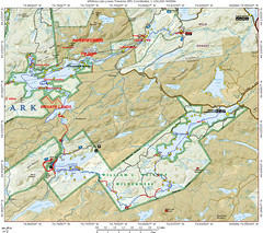
I attached a map of this trip, it's a general map but even with the latest Topo Software the rate at which land is acquired and added to the forest preserve the maps are just inaccurate. All the land we traveled through is legally fully state land, and the route is more accurate than the various trails on the ADK Topo Map 3D CDs which were just released a few months ago. Many logging roads are missing, and many that are shown on the maps don't exist anymore (if ever). While the USGS perhaps did the finest cartography of any nations lands, it simply fell behind over the last 50 years and most topo maps are borderline useless and hopelessly outdated.
On the map below red dashes are portages, solid red is hiking, blue dashes are paddling. Anytime you see a solid red between bodies of water it was a portage, however, we might have hiked it on an off day or it just blended together and looks solid. All the portages were "double carries". For non paddlers that means 1 trip with gear, return to start, get more gear/boat, and back to the next leg. basically, each portage/carry is x 3. To do single carries means a super light boat, well established smooth trails, and a short supply of gear (aka, "light is right" philosophy); we had none of the former, so we doubled. No shame in working hard, and far better than sitting home and wondering what could have been done with a lighter boat and fewer carries.
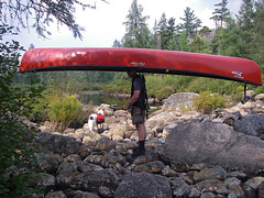
I have to thank Eric from KnuPack Systems. Simply put, carrying a 75lb boat was almost fun with his portage system (and I'm almost completely serious). I used an old Kelty Super Tioga that I bought for $5 and added his $45 retrofit kit. It didn't fit, nor was it guaranteed to, but with some last minute sanding I got it to fit. The bottom line, best $50 I ever spent. After a few hiccups, I actually preferred carrying the boat to the dry bags. Those still using yokes, or portage carts (absolutely no way a cart would work on the trails we did) need to get a KnuPac kit. Controlling the boat with a big external frame and some tag lines with the weight on your hips is amazing. It's like being a puppeteer. I actually beat Aim by 2 minutes on the Lily Pad Pond-Shingle Shanty portage, one of the roughest on the trip. the boat simply cleared a path thought the forest and I just followed it (ok sounds easy, but not really that easy). 5.5 total miles of carrying 80lbs (2 lbs of ballast on the stern +3lbs for the frame) and not a single back or neck ache once everything was fully adjusted.
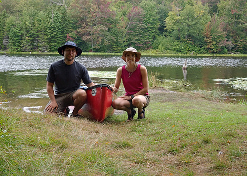
Of course a full detailed trip report with photos will follow at some point in the near future.....
BY THE #'S
- 10 total days
- 73.33 total miles traveled (hiked, paddled, portaged)
- 16.12 miles portaged/carried (no you didn't misread this, we did carry 150+lbs of gear, including a 75lb 16foot boat 16.12 miles over rough terrain on NOT yet established trails)
- 6.88 miles of various hiking including (former) logging road exploration, former great camps, abandoned train stations, view points, summits, etc
- 1 the amount of times the boat drifted away while not tied/removed from the water (hey the takeout was rocky/bouldery and rough, and it was a protected area so we figured it would be fine for a few minutes)
- 100m the distance I had to swim to get the boat
- 9 days of fair weather
- 1 day of rain
- 8 wind days (white caps on the lakes)
- 90+ liters of water Aim filtered
- 3000 meters swam (swam just about every day, and generally not to chase runaway boats)
- 0 active roads seen or crossed
- 0 motorized vehicles seen/heard in 8 of 10 days (day 10 saw a float plane land on Lows 2 X, heard logging while on Clear)
- 4 rest days/ 0 mile days (not exactly true, we paddled, swam or hiked each and every day but stayed 2 nights at the same camp on rest days)
- 6 travel days
- 5000 saw strokes (okay, I have no idea, but I cut a lot of wood, including some on the portage "trails")
- 1 leech bite (over 10 days this is an amazingly low #)
- 2 the amount of hours it took me to realize the leech was on me
- 2 the amount of hours it took to stop profusely bleeding after I removed it (there was blood pooling in the bottom of the boat that I had to sponge out)
- 5 blisters
- 50+ cuts (per person) from briers, thorns, branches, entire trees, and assorted trail debris
- 1 perplexed look on the rangers face day 1 when we informed him of our plans while sitting on the rocks by our campsite getting some sun (hey, I understand, I look like a meatball and Aim like a string bean, neither like we could carry enough or move far enough to complete this trip)
- 1 relaxed look when that ranger realized we had fully researched our plan and we're aware of the difficulty
- 1 perplexed look on my face when the ranger said "yeah, someone flagged the trail to Harrington but we don't know who?" Huh? isn't that the DEC's (rangers) job?
- 1 hour of paddling head on into 2 foot swells on lows lake with a 10-15mph head wind the lake literally looked like class III whitewater as we paddled into it
- 3 # of officially marked portages
- 9 # of total portages
- 0 people seen on our portages
- 0 people seen on interior lakes that required portaging
- 4 # of touring kayaks we beat from Grass Pond on the 12 mile trip out Sunday morning into a slight head wind and pouring rain with a loaded open high volume tripping canoe!!!
- 4:15 min time is took to paddle 12 miles and portage .53miles (total) from Grass Pond to Hitchins.
- 1 # of chipmunks I was forced to kill because people fed them (a fed animal is a dead animal)
- 1? # of chipmunks that broke into my parked car, ate all the sunflower seeds, pooped on the seats, ate gum, rummaged through the glove compartment, and slept in the backseat for several days!!!
- 110 percent satisfaction of the efficiency we got everything done on travel days
- 10/10 fun factor on this trip!!!
technorati tags:ADK, Daks, Adirondacks, paddling, Whitney Wilderness, portage, carry, wilderness, canoe, camp, campsites, New York State, Forest Preserve, Adirondack Park, Adirondack, hiking, backpacking, forest, Old Town, Discovery, Scout, Mountain Visions, Pentax, K10D, W20, ist D, SLR, Lake Lila, Harrington Brook, Hardigan Pond, Lily Pad Pond, Little Salmon Lake, Little Salmon Outlet, Lows Lake, Hitchins Pond, canoe traverse, photography, Shingle Shanty Brook, Mount Frederica, Grass Pond, Bog Lake, Clear Pond, Rainier Brook, camping, expedition, kayak, DEC, Forever Wild, Rock Pond, chipmunk
Blogged with Flock


Enjoyed the article and especially th e photos you posted on TPF.
ReplyDeleteTexasTrails from TPF