


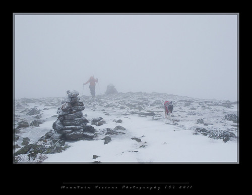
 |
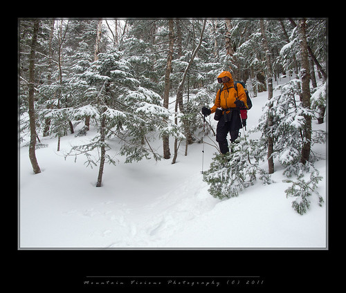
| Dave descending Mount Adams via the Air Line |
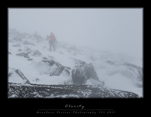
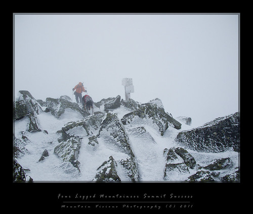
“I didn’t mind the whiteout, it was the first time in a while my mind was clear.”
My partner said something like that after we were the only group (2 humans and a trail dog) to summit Mount Adams, New Hampshire’s second highest peak, on Saturday March 12th. Although other groups would try, with one group turning around less than 100 vertical feet from the summit as they ascended directly into the strongest headwinds, there was good reason we were the only group. It was quite warm and foggy for a winter day, upper teens to mid 20s depending on elevation, actually perfect temps for the formation of rime on everything from our gear and clothing, to our exposed hair. The winds were gusting to over 50mph, with sustained 30mph the norm. When combined with the fog and blowing snowfall, it created challenging conditions to navigate. At times visibility was only 10ft, with the average being more like 30ft. There were moments it would clear up to maybe 200ft visibility, but those moments were rare and so fleeting that you would miss them in a split second.
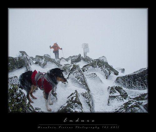
 |
| Colvin leading Dave up the summit of Mount Adams |
Of note, this was Colvin’s 3rd trip to the Northern Presidential’s and his 3rd summit (2 in winter, 1 spring). His first overnight backpacking trip was at the end of March in 2010, and it was to Gray Knob. At that point, after working with him for a month, he was just trained well enough to be trusted off the leash and comfortable enough to ascend and descend a trail as steep as Lowe’s. He hadn’t yet been above treeline or experienced the adversity of the alpine world. Though all that changed in March 2010.
Jumping ahead to March 2011, Colvin is turning into quite a trail dog. He is now carrying a loaded pack, he is fearless on steep slopes, and he isn’t afraid of 50mph winds. As a matter of fact, Colvin led the way up Lowe’s Path to Mount Adam’s almost without any trouble or hesitation, a sign of how much confidence he has gained in a year. The only spot he was uneasy was the steep icy descent off Adams 4, but I eased him down it and he was fine the rest of the day. He also led the way through quite a bit of the descent on Sunday, including a few spots that offered steep drops on the Cabin Cutoff. On a less interesting note, he went up and down the steep loft stairs at Gray Knob without any prompting. Last year I had to carry him up and down kicking and screaming. I suppose those stairs look mighty easy after you’ve been training to climb vertical ladders. Without a doubt he is gaining confidence and the skills to be a good trail dog for years to come.
 |
| A rime covered Colvin ascending Lowe's Path with Dave in the background |
As for how Dave, Colvin and I got ourselves into this:
Dave flew in from Pittsburgh Wednesday night, and we started out on a Thursday morning in snow and sleet towards NH. The drive took a little longer than I usually do it in. because of the weather and single lane road traffic. Even so, we were in Randolph in just over 5 hours including several stops, the time was due to a few more tweaks in my perfect route. At this point, I now have all the fat trimmed from the drive, and my average speed is over 50mph. I can be in the Northern Presidential’s in under 4 hours from the Capital Region New York. It’s exactly 222 miles to the trail head. I’m pretty much in heaven with my location having access to the Gunks, Catskills, Adirondacks, Greens and Whites whenever I get the urge to visit.
Arriving at Lowe’s Store in Randolph at 2:20pm, the skies had held up through NH. As we put our boots on in the store, I asked the people in Lowe’s if the forecast had changed, they said, “We are supposed to be getting rain, sleet, snow but none of it has arrived yet...we'll see” Our biggest fear was having to hike up to Gray Knob in the pouring rain in 35 degree temps. If you have any outdoor experience you probably know that the absolute worst conditions are freezing rain. You get soaked, you get cold, and you can’t add insulation because you will either overheat or wet out all your warm clothes for camp. Your only option is to wear as little as possible and hike as fast you can. We of course had all our gear packed in waterproof sacks, in a waterproof pack liner, so we weren’t concerned about the packed gear.
We started out on the trail in good conditions, snow bridges across all the brooks, decent snow under us. As we ascended the trail got steeper and more difficult to climb with the 50-60lb packs. I have older MSR Denali snowshoes, I was wearing the original lace-up model with my leather boots. These are great shoes and were cutting edge in 1998 when they came out, but recently MSR and Tubbs have surpassed these snowshoes in many regards. The issue with my old Denali’s is the warm wet snow was snowballing under them and they don’t have heel “televators”, which are essentially bars that level your heels (by raising them) as you ascend. Between the snow balls, my foot being back a little far in the binding and having to angle my crampon into the slope, I would sometimes walk 3ft forward and slide 4ft back on the very steep sections. From just below the Log Cabin the trail gets very steep, it levels off a bit between the cabin and 3500ft, but the last 1000ft comes pretty aggressively, and this is where I was having the most issues. Because the trail is so well traveled it also gets very icy in spots. By 4000ft I was mentally tired of carrying what I’d guess was a 60lb pack at that point with all the water drank.
Regardless of my sliding issues we made it to Gray Knob in about 3:40 minutes. I think book time is around 3 hours, but the good news is the rain never came. We stayed fairly dry.
When we got to Gray Knob the caretaker, Garrett, was -for a caretaker- uncharacteristically unhappy to see us. I guess he assumed we were idiots for coming up in the impending weather conditions, which had been forecast for days and were forecast to continue. More than likely he assumed he would have to endure a soaking winter rain to rescue us after we did something stupid. Though because we had 3 remaining days to bag some peaks, Dave and I had little intention of doing anything more foolish than mountaineering itself. We had absolutely no plans to summit in rain coupled with 50-70mph winds, which combined feel like a fire hose was unleashed on you while standing in a freezer.
 |
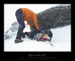
| Colvin enduring a gust of wind at his back as he waits for his slower human partners catch up. |
After a night of Gray Knob being pounded by winds, we got up early Friday morning and noticed a few inches of fresh wet snow, a good sign. Then we checked the forecast, and decided things were gonna get a lot worse before they got better. Dave and I went to fill up on water before the real rain started. Our only goal Friday was to not get wet or die of boredom. It rained steadily for much of the day, at times extremely heavily.
After lounging in the sleeping bags, rigging up Colvin’s harness and working on an equalizing system, a little reading and a few short walks, we managed to kill an entire day. We also did a bit of shoveling and helped keep the hut in order. We eventually cracked Garrett, who by now figured out we weren’t complete morons and that my dog was both well behaved and that I didn’t let him do as he pleased. I always say, there are very few problem dogs, only problem people with dogs that act like dogs naturally act.
Friday night we again had the place to ourselves. After a good nights sleep we woke to what appeared to be snow falling and not rain. A good sign, indeed.
Forecast was for typical alpine summit weather 30-50+ winds, snow, fog, temps 20F colder than the valley.
We packed our summit packs, checked the forecast once again and took off up Lowe’s Path towards Adams 4, now renamed (officially) to Abigail Adam’s. Conditions were perfect for crampons bottom to top. No need to mess with snowshoes, or bare boots. It was frozen rain soaked snow below treeline, and a mix of hard wind blown snow and mixed ice above treeline. Though not as much snow as the end of March last year, there was very little exposed rock. It was perfect crampon conditions.
I’m not sure if Dave was a little nervous at first because he asked me if I knew the way by memory. I said, I’d been up this trail and various others probably 30-40 times over the last 10 years so I definitely had an idea where I was going. When we got to Adam’s 4, that experience and built in GPS system in the human brain took over. When we dropped over Adam’s 4 we didn’t see anymore cairns and it was full whiteout. We pulled the map and compass out, as well as the GPS. However, I knew that after Adam’s 4 we crossed a big snow field perpendicular to the fall line, essentially following a contour. This snowfield is crystal clear on a 1:24,000 resolution topo but not that clear in the typical store bought maps. I had my 1:24,000 topo printed on waterproof paper and this confirmed my memory. We took a compass bearing in the direction of Thunderstorm Junction just to be sure.
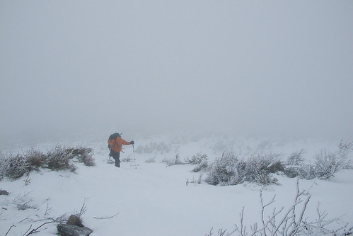 |
| Pushing above the Krummholz Zone |
I’m not sure where we crossed the snowfield in relation to the cairns, we never saw them again. I believe it was below. Regardless, we hit Thunderstorm Junction as expected. It was so whited out Dave asked me if this was the summit. I laughed and said, it’s a shame you can’t see it, but it’s about .3 miles away and 300ft above us.
We got to the top of Adam’s from Thunderstorm Juntction in what seemed like record time. Between the whiteout and the howling winds you lose any concept of time or space. It’s similar to hiking at night, only without the headlamp.
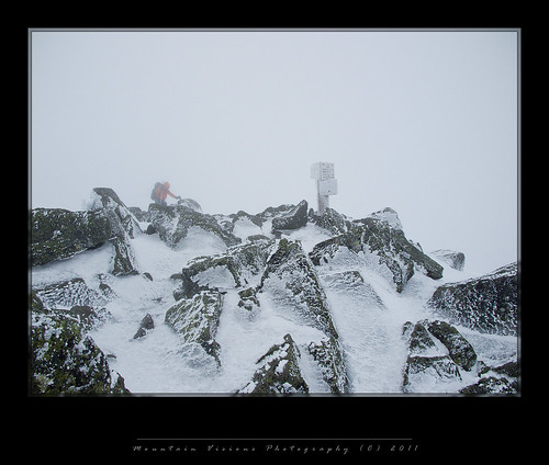 |
| Dave cresting Adams summit cone, he would be one of only 2 people and a trail dog to summit that day. Many others turned around in the face of strong winds and whiteout conditions. |
I got to the summit a minute or two before Dave, waited behind a boulder to get a shot of him cresting. Then we moved as quickly as possible to get to the leeward side of the summit and drop down a few feet. Nothing makes a better wind break than a mountain itself, and we rested behind some boulders. The wind and snow were still blowing, but it was a lot warmer and more protected where we were.
Dave added some layers, I got out my face protection. It really wasn’t cold up there, though with the wind the temps were about 0F. I warmed Colvin’s face and ears, gave him some doggie energy bars and we were back off to the summit and down the Airline Trail with plans to summit Mount Madision as well.
On the descent we met the only other group we saw all day, they were really just 150 or so vertical feet from the summit when we saw them. They asked me how far, and I said 10 minutes -maybe- with the wind coming at them perhaps more. My understanding is they turned around just below it.
We intersected with the Gulfside Trail, and ended up going a little too far and wound up at the top of the King Ravine trail. Again, I knew where we were based on having climbed the King Ravine and remembering it’s exit from the ravine. We cut across the terrain back to where we needed to be and started our descent to the Madison Springs Hut.
 |
| Dave is repacking for the descent as we hide behind a boulder on the "sheltered" side of the mountain. You may notice the blowing streaks of snow? |
As we descended down towards the Madison Springs Hut, which is closed in winter, Dave lost a crampon. It was at this point I was beginning to become more concerned with Colvin. He had no hood or hat, and he’d now been in 50mph winds and 0F windchills for several hours. I periodically rewarmed his ears and face with my hands but he was getting cold and the winds were getting no less extreme.
I wanted to ascend Madison and I am certain we could have done it. I’m certain Colvin could have made it, but there is a point to where you have to consider every ones safety, and Colvin had done awesome to this point. I did not want to push my luck and turn this positive learning experience into something negative. The rationale behind this was while the wind was at our backs up Madison, it would be in our faces for almost 3 miles back to Gray Knob. Head winds are colder and more dangerous, and it’s why people who a lost instinctively walk with their backs to the wind despite needing to go in the other direction to get to safety.
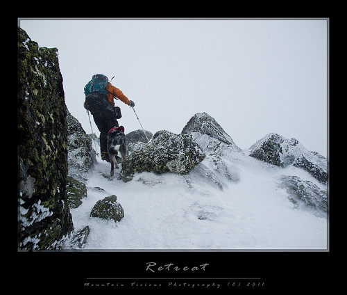 |
| Dave and Colvin retreating to the leeward side of Mount Adams to escape the wind |
Because we would be in whiteouts, possibly getting dangerously close to the top of the King Ravine headwall; and because Colvin, while having claws and directional paw pads (like climbing skins) didn’t actually have steel crampons, I decided to rope him up. Short roping him turned out to be unnecessary, as we stayed well south of the headwall, and the terrain wasn’t quite as icy as it was in other spots. It was good practice for both of us using a tied off Kiwi coil and his Ruff Wear Doubleback technical climbing harness.
After we turned around just above Madison Springs hut we returned via a combination of the Gulfside trail and various trail-less maneuvers that eventually got us to the intersection of Lowe’s Path and the Spur Trail. By this point we were pretty confused as to our actual location, though I wouldn’t go so far as to say lost. Finding that sign was a nice thing since many signs and cairns were either covered in snow or not visible beyond a few dozen feet.
Although the Spur Trail option was more direct and got us to the safety of treeline faster, I thought Lowe’s was the safer option. People often get lost on Spur and wonder towards and into the King Ravine. Or they fall and slide into the King Ravine. More importantly, finding the entrance to the Spur trail at treeline is difficult. There have been times I have ascended via the Spur only to return and find my tracks completely gone, spending time and energy dodging spruce traps looking for the entrance.
Unlike out west, getting to treeline in the east isn’t really the goal unless you are in a survival situation. You need to find a trail that takes you down, or at least a trail entrance to below treeline. Our forest are too thick, which is why bushwhacking here is no small undertaking. Add in spruce traps and 6 feet of snow underfoot and you actually have a situation where getting to the trees is a real safety problem in itself.
So we started down Lowe’s and took a bearing, then we spotted some cairns and were moving quite quickly without the need of the compass and map, so we thought. Something didn’t seem right to me, and it turned out later Dave said the same thing. It just seemed like we eventually started going in the wrong direction as the wind subsided some, and we never hit our landmarks. Of course my altimeter was way off, I hadn’t calibrated it in hours. The weather was all over the place with various fronts passing through playing havoc on the barometric pressure. So at this point I wasn’t relying on it for elevation. It turned out because the pressure had changed so much, it was off by almost 200ft at the end of the day. This is EXTREMELY rare for my Suunto Vector, and a sign of how quickly weather fronts pass through the Presidential’s. It’s also a real life example of why this is the most extreme small mountain range on earth! Fronts just pummel through the region causing massive changes in pressure and winds so intense that people often accuse me of lying about them. Yet, as the caretaker remarked when I commented on the 55mph winds forecast, “just a typical day above treeline in March.” I laughed, not at his statement but at the ridiculousness of that fact. 55mph is the norm, 70 and 100mph not uncommon. What is uncommon is a blue sky summit day without winds!
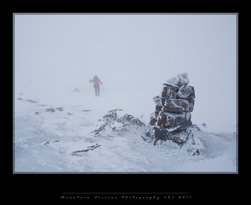 |
| Dave traversing a snowfield towards Thunderstorm Junction. Visibility is actually better than it appears, we can see cairn to cairn |
By the time we got to what was essentially the end of the Spur trail above treeline, we realized without a doubt we were not on Lowes as we could now see perhaps 200ft. We cut left (west) into the wind after the last cairn and realized we were way off as we crossed what was a fairly steep and icy snow field headed to where we thought we should be going. This was the correct direction and had we continued on that bearing we would have eventually hit Lowe’s, but at this point we were a half mile from Lowe’s because the Spur and Lowe’s wishbone away from each other. We pulled out the map, compass and GPS. Got our coordinates and tried to figure out where exactly we were. Unfortunately, my 1:24,000 map while having the UTM 1000m grid overlay had degrees and minutes on the edges. I don’t know why this was the case, as I use UTM almost exclusively with my compasses UTM corner ruler. This created a little problem that had to be solved. On the other hand I have no tools to measure degrees and minutes other than eyeballing them. UTM and the corner ruler became a useless tool and I had to get the GPS into the correct units (from UTM to degrees minutes) so we could roughly verify where we already figured out we probably were. You aren’t lost until you have no idea where you are. Even in a whiteout if you trust you compass bearing you will generally be able to get somewhere near your desired point.
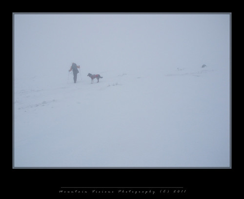 |
| Dave crossing the snowfield below Sam Adams as Colvin waits for me to catch up |
Dave roughly figured out we were someplace around the Spur at treeline using degrees and minutes, and I looked around and said I thought the King Ravine was due east from our position. If this was the case, the best thing to do was actually head towards the ravine at treeline, then backtrack west along the trees till we found the Spur Trail.
Colvin was very cold at this point, laying down in a ball on the icy slope trying to not slide down, as we were all taking the fall force of the winds that we had now turned back into. I told Dave we needed to head for the trees and the edge of the ravine and figure things out from there.
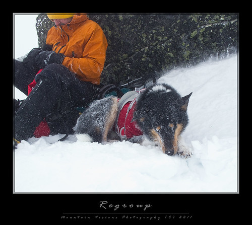 |
| Colvin resting on an icy slope behind a leeward windbreak below the summit of Mount Adams |
Once in the trees the temps jumped 20F instantly as the wind ceased to be a factor. I could see the edge of the ravine and I knew the trail was maybe 500ft from the edge of the ravine lip. So we began searching. Once in the trees, snowshoe and boot tracks hang around a bit longer. We spotted what we thought was the trail and started to follow it, shortly after we found the snowshoe tracks and what felt to surely be a trail underneath.
Descent was quick and effortless. We stopped by the Knights Castle hoping for views of the ravine. Nothing to be seen.
Reaching the intersection of Gray Knob trail, I stopped by Crag Camp and spoke with some members of the group that had just missed the summit. They were a nice group of French Canadian’s, they really liked Colvin and we chatted for a while. It turned out they were a mostly inexperienced group and most turned around at Adams 4, others made it further. As we stood there, golden sunlight briefly illuminated the valley below, and the King Ravine appeared in front of us. They took their cameras out, happy to capture a fleeting view. Moments later it was gone!
I hiked back to Gray Knob where for the first time in days we would have to be social and share space with many others. I think about 12 people were up there, plus another dog. The dogs owners were experienced hikers and knew Colvin (the mountain) and liked Colvin the dog. Many other friendly people were at the hut that night as well. Losing our abundant space was tempered by the friendly atmosphere. So friendly in fact that two guys shared their water with us, saving us what I consider the longest “flat” .2 miles on the world to a spring serving up perhaps some of the worlds best unfiltered spring water.
Sunday I figured we’d sleep in a bit and head down around 11am. Almost everyone else was up at 6-7am, so I woke Dave up, he was a bit shocked I was out of bed before 9am. We ate breakfast, packed and were on the trail by 10am.
I really didn’t want to descend Lowe’s, which if I haven’t already mentioned is probably my least favorite trail in the Presidential’s for many reasons. Primarily it’s unscenic, secondly it’s a heavily traveled trade route to get to the shelters, and as such it’s heavily traveled by day hikers because it’s packed down and easier hiking. I actually haven’t hiked Lowe’s in years except during the winter months. I was thinking Spur Trail to King Ravine trail, Garrett who by this point almost seemed a little sad to see us go, and even complimented Colvin as being a really good dog, mentioned the Hink’s trail. I’d actually never hiked the Hink’s trail in all my years up there. So I said, sure lets go for it.
| Colvin at the end of the Hincks Trail |
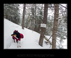
Doing Hincks wasn’t the easy route home. Hincks is steep, and the trail was unbroken crusty snow. Plus, because it was less packed down, the trail was higher into the tree canopy. Every few feet I’d dump snow down my back from the spruce bows hanging over the trail. We stayed dry for 3 days, but between the wet falling snow and the snow that fell off the trees, I was soaked by the time we got to the Log Cabin. Descent was pretty slow and deliberate. Eventually we hooked up with the Randolph Path and the Cabin cutoff which trends uphill will rolling from Hink’s to Lowes. In the end it took us 3 hours, several breaking trail to get to the Log Cabin. I mention the 3 hours because Log Cabin is perhaps 15 minutes of glissades from Gray Knob. Why? We were hiking out and doing something different is more of an adventure than glissading down a trade route. Dave was all for it to. A good chance to see a little more of the topography of the White Mountains and add some mileage to the trip that lost a day to the rain.
So we took 3 hours to go what could have taken 15 minutes and still had 2 miles and 2000ft to descend. In a total of 4 hours we were changing at Lowe’s Store though the lower trail had changed a lot over 3 days. Gone were the snow bridges over the small water crossings, as well as several inches of snow cover. Replacing it was several feet of slushy snow like material.
 |
| Dave descending the Hincks trail |
The drive home was pretty fast, though we ended up driving back via North Conway...your first hint that you are taking a bad route if that is the way you go. It took us 4:20 from North Conway which adds 40 miles and almost an hour to the drive, total drive time 5:30 from the trail head or an hour and a half more. Though we thought the side trip to EMS or IME might might be worth it for some good as-is or consingment merchandise, and the lack of sales tax was inviting. Sadly despite the large store, I have better selection locally and NY needs my tax money more than NH.
As always it was a fun adventure, and I appreciate Dave making the commitment to come all the way from Pittsburgh to join me. It was obviously very rewarding to safely summit when others couldn’t, it was also very rewarding to see how far Colvin had come in just a year. Caney was the ultimate K9 mountaineer, but it looks like Colvin is going to do his best become a great K9 mountaineer himself!


No comments:
Post a Comment