


George and I left a little later than expected, but were on the road a little before 8am. We took the scenic route to Franconia Notch and it took almost 5 hours including several stops to eat, gas, and a few detours (dirt roads that dead ended, missed turns, etc). Since we were being drenched in torrential rains that were forecast to continue all day, there was no particular rush. Hiking Saturday was out of the question, and our main hike had always been planned for Sunday.
We arrived at
The basic plan was to have a good meal Saturday night, and what better place than
In the Northeast we have this thing called weather. It's not necessarily the worst weather by sheer numbers. For instance many places are colder, many are wetter, many receive more snow, many have stronger winds (although Mt Washington DOES hold the official record for highest recorded wind gust in the northern hemisphere), but what makes our weather so unique is the speed in which it deteriorates to the extremes.
After checking the latest higher summits weather report, which changed from temps in 40s and 25mph wind gust to highs in the 20s and 70mph wind gust, George was a bit worried that he might have been a little under prepared for the weather that had now been re-forecast. Fortunately, if you need gear then
Having killed plenty of rainy day time while shopping, we had worked up and appetite for the main course at
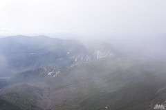
After a good nights sleep under continued rain, warming temps and increasing winds, we awoke Sunday morning to clearing skies and falling temps. A high pressure system with winds from the north was pushing in, clearing out the rain, and causing an inverted temperature profile.
Inverted temperatures are rare in the mountains, but the anomaly is such that instead of air getting colder as you increase in altitude (typically 3-4*F per 1000ft), it actually gets warmer as you go up. We saw this while driving back from
We started the Franconia Ridge traverse with temps in the mid 40s from
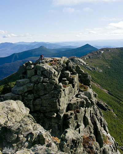
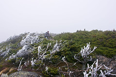
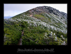
Along the way to Greenleaf, starting at around 3000ft, there are some great views across to the Franconia Ridge, which the Bridle Path parallels for most of it's approach to the hut. It was fairly warm, and fairly windless at these rock outcroppings on the edge of the ravine. Looking across at the
 We spent way too much time messing around at Greenleaf, almost 40 minutes in total, we spent much time debating the actual temperature which was probably about 5 degrees above freezing. Finally back on the trail we lost some elevation and than began our ascent to the summit of
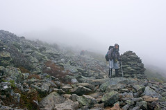
 As we ascended above treeline the wind continued while the temperatures dropped. We met some hikers at around 4800ft descending with an injured member asking for some ibuprofen. While talking with them we inquired about the summit conditions, which they said were around 29F and windy. Another hiker had previously told us, “windy, but not knock you over windy, 40-50mph...not 70s or anything crazy...some rime ice but otherwise dry.”
 As of that point the higher summits forecast was on the money, and it seemed like George was having some doubts. After all, assuming the forecast continued to pan out as promised, we had some rain/sleet followed by 70mph winds and continued falling temps on the way. We are talking wind chills approaching the single digits with hurricane force gust.
 Finally, just below the summit, after filtering ice cold water in a spring/runoff, we met another hiker who had passed us while we were filtering. George asked him how the summit was, and he said he turned around just short of it; too windy, too cold. At this point George pretty much decided we were turning around at the summit, which of course I had no intention of doing. The winds were brutal, and it was cold, but neither of us was wearing all that much, and we were plenty warm. It was also dry, and the trail was mostly free of ice and snow. Basically as close to perfect as you find in these mountains, aside from the wind of course.
I convinced George that 1) we were up here to let nature beat the crap out of us 2) from the summit of
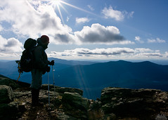
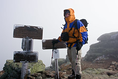 We geared up for the summit with thicker gloves and face protection. The winds were nasty, cold and blowing from the north at around a constant 50mph. There was freezing fog, and at times limited visibility. We took a few summit shots, and descended to the south with the wind at our back. Just as we dropped below the summit we saw two hikers sitting on the south side of
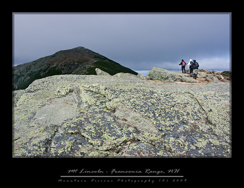
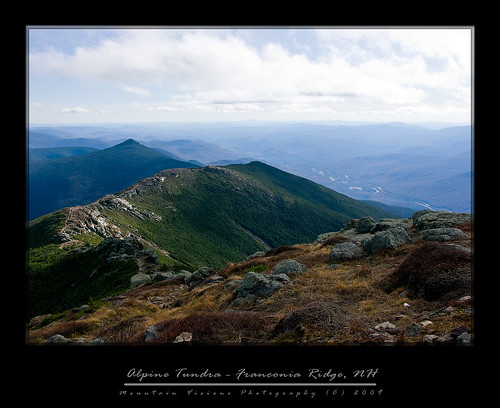
 Other than the occasional bits of hail falling from the sky, the rest of the ridge was an enjoyable walk. The footing on the Franconia Ridge is easy, and the scenery makes the hiking a pure joy. We stopped for lunch just to the south of
 The rest of the ridge was uneventful other than seeing the barefoot hiker. I know people do hike barefoot, but I simply cannot imagine negotiating talus, and NH granite with my bare feet. Not to mention walking through mud and ice cold water.
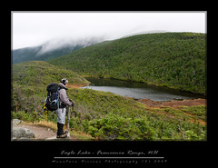
The descent of the Falling Waters trail to complete our loop was as craptacular as expected. The Falling Waters trail is rooty, rutted, rugged and wet. The upper portion descends steeply, lacks views, and is dark and dank. The lower portion, while beautiful and scenic has several water crossings of Dry Brook. In low water this isn't an issue but with all the rain the lower trail was very wet, slick, and water crossings were high.
Just above the 150ft
Having lost a lot of time dealing with the wetness, and slick nature of the trail, it was getting dark. We finished the 1/2 mile and 2 water crossings with headlamps.
We ran into a one last group, and they seemed a little confused, but I told them they only had 100 vertical feet till the trail head, and we were close. There was a spot the trail appeared to cross the brook, or continue on it's bank. I told George to wait while I checked it out, and then I called for him to come this way. I thought he heard me and started down the trail, turned out he didn't.
I arrived back at camp at 6:35, about 10h30m after we started, we climbed 4050 feet over 9.8 miles. At 6:45, after I'd changed my boots there was still no George at camp. 6:55 came and I knew there was no way he was that far behind. So I ran the half mile to the trail head where the couple that we passed were hiking out to. I asked them if they saw him, and they said he passed them and then started back up the Bridle Path. I was impressed; he was obviously feeling so good he decided to do it a second time. Then reality sank in, he was going in the wrong direction, which fortunately was mostly (entirely) up hill. I knew he would eventually figure it out, so I wasn't too worried. Still I ran up the trail calling out his name, and fortunately he'd figured out his mistake sooner than later.
And here lies a lesson for the kiddies: 1) never split up without clearly going over the plan 2) make sure everyone is carrying a map 3) make sure everyone is prepared to spend a night
I usually print out a map for everyone, but I forgot this time. Plus, I wasn't particularly worried since it was a simple loop hike. Because of the rushing water, George didn't hear me say “this is the right way, lets go.” However, he was fully prepared to spend a night out, and probably pretty comfortably at that.
Back at camp it was dinner time. My menu was Black bean soup with blue corn tortilla chips, reheated pad thai from lunch the previous day, Stove Top stuffing, and red wine. George had his trail comfort food of chicken and rice.
After dinner and a little down time relaxing under the stars till it was time to sack out.
I managed to get the last 2 innings of the Yankee game in my tent via my Palm Pre while roaming off Verizon. I found this ironic because George who has a Verizon phone couldn’t get service at all. Barely hanging on to the 12:01am clinching finale as the wind whipped, I was sound asleep by 12:02. I wouldn't wake up again till 8:30am, and after hitting the virtual snooze button for an 1 hour I was back to the land of the living at 9:30am.
After breakfast and drying our gear out we were off to hike a little peak south of the campground on our way back home.
The trail up Pemigewasset is probably one of the worst trails in NH. Absolutely awful, it follows a creek bed, much of the way, and is extremely wet and hard to get a good rhythm going. On the descent I was tired of the abuse of my back and knees. The terrain was easier than the trail would suggest, so I cut cross country and mostly kept up with George who descends faster than me. Going off trail was drier, and softer, and I could get descent strides rather than tip toe between rocks.
Eventually I lost George and the trail, I then followed the creek contour down hill till the trail crossed it again close to the end of the trail. Hitting the trail wasn't a necessity but sort of important since it negated having to run across 4 lanes of highway to get back to the trailhead at the Flume Gorge visitors center. Including the bushwhack, I ended up finishing about a minute behind George.
Back on the road at 3pm we were home by 7pm, including 25+ minutes of stops.
All in all it was a good weekend, and physically my toughest weekend hiking in the mountains since early summer. Over 2 days we covered 12 miles and 12,000ft gained and lost over 12 hours of hiking. By no means record setting, or even noteworthy. Quite frankly the little hike on Monday was harder than the Franconia Loop which I rate as a beginner hike, with the caveat that it is so comparatively easy that you see vastly unprepared people hiking with nothing more than a single Poland Spring bottle. I know despite the great ridge top hiking, George was a little disappointed. I usually drag him up some semi technical scramble and this time we never had to use our hands.
Nevertheless, considering I've literally done nothing remotely exerting between July 2009 and early October 2009, while adding a solid point to my BMI, we covered a decent amount of ground, and had a good time. I hopefully gained a little more momentum towards regaining fitness so I can enjoy my time out there a lot more on future trips.
The hardest part of regaining your fitness is knowing that the first few weeks are going to suck big time. Your mind only remembers what you could do back then, your body only knows what you can do now. Retraining both isn't easy, but in a short time they meet somewhere in the middle, and eventually they trade places. Then you have to retrain your mind to realize it's not about what you can do now, but what you want to do.
I thought about Caney a lot up in NH, in part because I think the first hike he did in NH was the Falling Waters trail Memorial Day weekend 2000. While driving up Saturday on NH 25A we crossed a river access site, I thought about him and how he got in that cold water and lay down after we had a long, hot and hard weekend in the Northern Presidential's in June 2008. That weekend was just over a year ago, and he dominated the King Ravine trail (a trail the guidebook says is not recommended for dogs) on a 80F day with typically oppressive Northeastern humidity. A few months later I did it with humans without him because he was not 100%, although I wish he had come because he never really got to 100% again. That human partnered scramble took longer, there was more complaining, and they were undoubtedly less competent than my canine partner. While I've hiked with a lot of people elsewhere, I've logged more miles and had more crazy days in the


No comments:
Post a Comment