


Current Severe WeatherWarnings for Western Essex, New York : Weather Underground | ||
This weather change from warm to cold is exactly what brings in the lake effect snow that makes national headlines, as people around the country think Buffalo is the snow capital of the world. It's the same weather that pounds the Tug with 400 inches of snow, and funnels it's way into the Adirondacks.
Looking at the long range forecast, around the northeastern North Country, it looks really good.
Lake placid isn't expected to break freezing for it's daytime highs more than a few days over the next 14 days. This is weather more typical of mid winter, not late fall!
When we get lows around the single digits, and highs right around freezing, we get two things. Fast ice formation, and regeneration. The best ice winters like 2000-2001 are fairly mild but seasonal. Meaning cold nights, and days with below freezing temps. We don't need 3 months of 0F days and -20F nights, just nights around zero and days in the high 20s, and voila plastic ice all winter that looks virgin after a few days of regeneration.
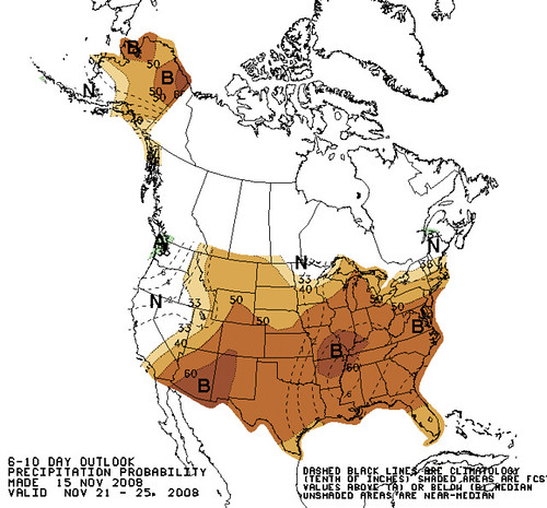
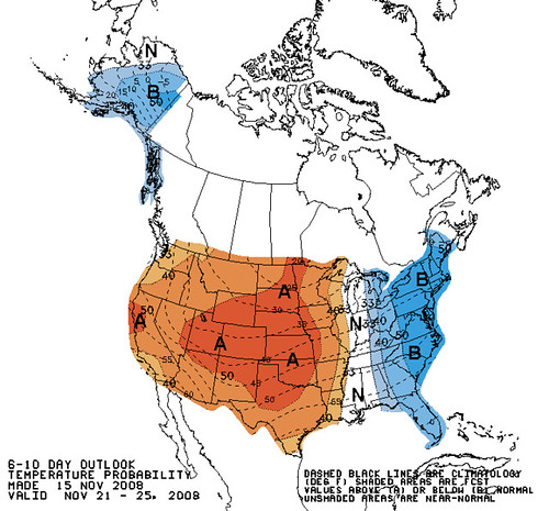
The bad news? We are below normal for rainfall, but better than last year where we were extremely below normal.
This year, we are a little off the 20 year average. Worse, we are not forecast to see a tremendous amount of precip in the next month. The result, if it snows at the lower elevations it needs to stick around. Of course days of snow cover is one of the big problems with our regional climate change (i'll concede there is no global warming here for arguments sake). In the last 20 years our snowfall has fallen off somewhat, but the bigger issue is that our days of snow cover has significantly lowered, and the result is you need a base of snow for accumulation to be deep and lasting, so less cover creates a viscous cycle of low snow depth winters which then give the impression we are getting less snowfall overall.
So keep your fingers crossed, and you might be climbing the trade routes on ice fat enough for a 22CM screw before Thanksgiving, and no doubt the Tug will have plenty of snow for a long winter of XC skiing in just a few days!! The issue really becomes how long till the Catskills, Helderbergs, Mohawk/Hudson Valley and Berkshires catch up. These areas are MUCH more impacted by regional climate change than the higher elevations and the North Country.
But more importantly, keep your fingers crossed that we go back to the days of a single mid February melt out, rather than the pattern the last few years of several mid season melt outs that take a few weeks to return to winter conditions. And just in case things remain status quo pack a bottle of DEET for those 50F winter days when the mosquitoes find a few hours to come out!
Bad news:
Good News:
More Good News:
| NWS Forecast for: Keene Valley NY Issued by: National Weather Service Burlington, VT | ||||||||||
| ||||||||||


Today: A slight chance of rain showers before 1pm, then a chance of rain and snow showers. Mostly cloudy, with a temperature falling to around 33 by 5pm. West wind between 14 and 18 mph. Chance of precipitation is 30%. Little or no snow accumulation expected. Tonight: A chance of snow showers. Mostly cloudy, with a low around 23. West wind between 7 and 16 mph. Chance of precipitation is 50%. New snow accumulation of less than a half inch possible. Monday: A chance of snow showers. Mostly cloudy, with a high near 33. West wind between 3 and 9 mph. Chance of precipitation is 40%. New snow accumulation of less than a half inch possible. Monday Night: A chance of snow showers. Mostly cloudy, with a low around 19. North wind around 5 mph. Chance of precipitation is 40%. Tuesday: A chance of snow showers. Mostly cloudy, with a high near 27. North wind between 6 and 9 mph. Chance of precipitation is 40%. Tuesday Night: A chance of snow showers. Mostly cloudy, with a low around 14. Chance of precipitation is 30%. Wednesday: Partly sunny, with a high near 26. Wednesday Night: Mostly cloudy, with a low around 11. Thursday: Mostly sunny, with a high near 27. Thursday Night: Mostly cloudy, with a low around 10. Friday: Mostly cloudy, with a high near 27. Friday Night: Mostly cloudy, with a low around 16. Saturday: A chance of snow showers. Mostly cloudy, with a high near 27. Chance of precipitation is 30%. | |
| Point Forecast: Keene Valley NY 44.19N 73.81W | |
Blogged with the Flock Browser


Justin, so do you want snow, or not? :-)
ReplyDeleteHey, as far as I'm concerned, you can keep all of Massachusetts's snow, cos I certainly don't want it!
Oh, I want snow...but the realist says, the days of a winter with trails and lawns and valleys covered in snow are long gone. Now it's a few days to a few weeks of coverage at a time. Of course above say 2500-3000ft there is always snow even in a warm or dry winter.
ReplyDeleteI love the winter, such a fun time of the year! I even like driving in the snow (provided I don't actually have to be somewhere)!